You are here: Home > Network List > TA - USArray Transportable Network (new EarthScope stations) Stations List
> Station L15A Malad City, ID, USA > Earthquake Result Viewer
L15A Malad City, ID, USA - Earthquake Result Viewer
| Earthquake location: |
Tonga Islands |
| Earthquake latitude/longitude: |
-15.1/-173.5 |
| Earthquake time(UTC): |
2008/08/19 (232) 16:30:13 GMT |
| Earthquake Depth: |
8.0 km |
| Earthquake Magnitude: |
5.6 MB, 5.9 MS, 6.1 MW, 6.0 MW |
| Earthquake Catalog/Contributor: |
WHDF/NEIC |
|
| Network: |
TA USArray Transportable Network (new EarthScope stations) |
| Station: |
L15A Malad City, ID, USA |
| Lat/Lon: |
42.00 N/112.39 W |
| Elevation: |
1646 m |
|
| Distance: |
79.9 deg |
| Az: |
41.509 deg |
| Baz: |
239.197 deg |
| Ray Param: |
0.0486575 |
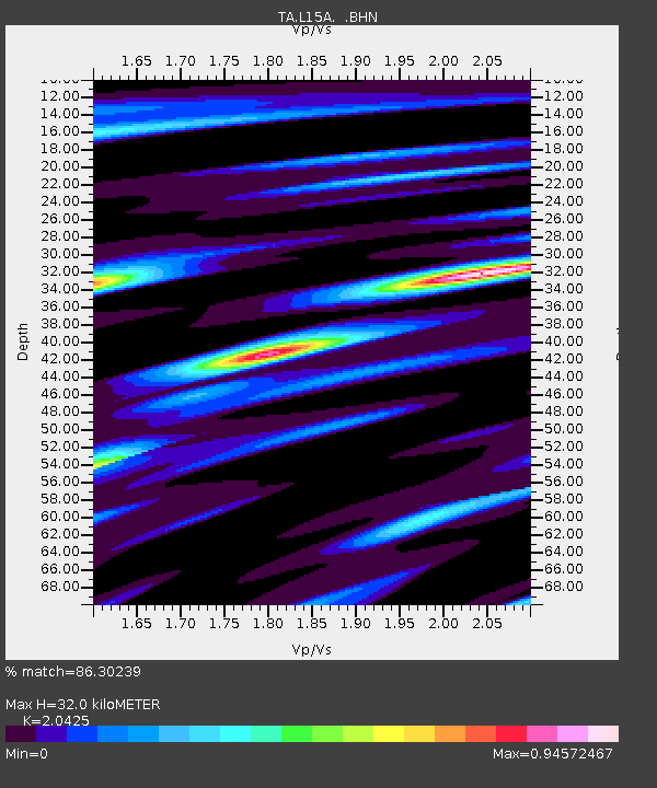
| Estimated Moho Depth: |
32.0 km |
| Estimated Crust Vp/Vs: |
2.04 |
| Assumed Crust Vp: |
6.279 km/s |
| Estimated Crust Vs: |
3.074 km/s |
| Estimated Crust Poisson's Ratio: |
0.34 |
|
| Radial Match: |
86.30239 % |
| Radial Bump: |
400 |
| Transverse Match: |
65.371315 % |
| Transverse Bump: |
400 |
| SOD ConfigId: |
2504 |
| Insert Time: |
2010-03-06 13:29:44.594 +0000 |
| GWidth: |
2.5 |
| Max Bumps: |
400 |
| Tol: |
0.001 |
|

Signal To Noise
| Channel | StoN | STA | LTA |
| TA:L15A: :BHN:20080819T16:41:50.949014Z | 6.7527866 | 4.2080993E-7 | 6.231648E-8 |
| TA:L15A: :BHE:20080819T16:41:50.949014Z | 1.4948554 | 8.31075E-8 | 5.5595677E-8 |
| TA:L15A: :BHZ:20080819T16:41:50.949014Z | 3.521599 | 1.6285775E-7 | 4.6245397E-8 |
| Arrivals |
| Ps | 5.4 SECOND |
| PpPs | 15 SECOND |
| PsPs/PpSs | 21 SECOND |


