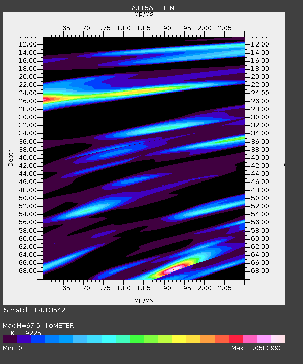
L15A Malad City, ID, USA - Earthquake Result Viewer

Earthquake location: Lake Baykal Region, Russia
Earthquake latitude/longitude: 51.6/104.2
Earthquake time(UTC): 2008/08/27 (240) 01:35:32 GMT
Earthquake Depth: 16 km
Earthquake Magnitude: 5.8 MB, 6.2 MS, 6.2 MW, 6.2 MW
Earthquake Catalog/Contributor: WHDF/NEIC
Network: TA USArray Transportable Network (new EarthScope stations)
Station: L15A Malad City, ID, USA
Lat/Lon: 42.00 N/112.39 W
Elevation: 1646 m
Distance: 81.5 deg
Az: 26.662 deg
Baz: 337.948 deg
Ray Param: 0.04753027
Estimated Moho Depth: 67.5 km
Estimated Crust Vp/Vs: 1.92
Assumed Crust Vp: 6.279 km/s
Estimated Crust Vs: 3.266 km/s
Estimated Crust Poisson's Ratio: 0.31
Radial Match: 84.13542 %
Radial Bump: 400
Transverse Match: 76.2111 %
Transverse Bump: 400
SOD ConfigId: 2504
Insert Time: 2010-03-06 13:29:48.801 +0000
GWidth: 2.5
Max Bumps: 400
Tol: 0.001

Signal To Noise

ChannelStoNSTALTA
TA:L15A: :BHN:20080827T01:47:17.225012Z9.8604925.0306625E-75.1018375E-8
TA:L15A: :BHE:20080827T01:47:17.225012Z3.39330891.5728087E-74.6350294E-8
TA:L15A: :BHZ:20080827T01:47:17.225012Z1.63531411.3031016E-77.968509E-8
Arrivals
Ps10 SECOND
PpPs31 SECOND
PsPs/PpSs41 SECOND