You are here: Home > Network List > TA - USArray Transportable Network (new EarthScope stations) Stations List
> Station L15A Malad City, ID, USA > Earthquake Result Viewer
L15A Malad City, ID, USA - Earthquake Result Viewer
| Earthquake location: |
Tonga Islands |
| Earthquake latitude/longitude: |
-21.9/-173.8 |
| Earthquake time(UTC): |
2008/10/19 (293) 05:10:33 GMT |
| Earthquake Depth: |
29 km |
| Earthquake Magnitude: |
6.8 MB, 7.0 MS, 6.9 MW, 6.9 MW |
| Earthquake Catalog/Contributor: |
WHDF/NEIC |
|
| Network: |
TA USArray Transportable Network (new EarthScope stations) |
| Station: |
L15A Malad City, ID, USA |
| Lat/Lon: |
42.00 N/112.39 W |
| Elevation: |
1646 m |
|
| Distance: |
85.2 deg |
| Az: |
41.066 deg |
| Baz: |
234.961 deg |
| Ray Param: |
0.044923134 |
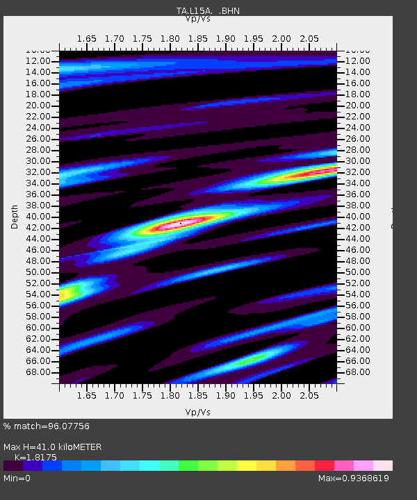
| Estimated Moho Depth: |
41.0 km |
| Estimated Crust Vp/Vs: |
1.82 |
| Assumed Crust Vp: |
6.279 km/s |
| Estimated Crust Vs: |
3.455 km/s |
| Estimated Crust Poisson's Ratio: |
0.28 |
|
| Radial Match: |
96.07756 % |
| Radial Bump: |
400 |
| Transverse Match: |
90.205414 % |
| Transverse Bump: |
400 |
| SOD ConfigId: |
2556 |
| Insert Time: |
2010-03-06 13:29:54.201 +0000 |
| GWidth: |
2.5 |
| Max Bumps: |
400 |
| Tol: |
0.001 |
|

Signal To Noise
| Channel | StoN | STA | LTA |
| TA:L15A: :BHN:20081019T05:22:36.074001Z | 60.798412 | 6.1601295E-6 | 1.0132057E-7 |
| TA:L15A: :BHE:20081019T05:22:36.074001Z | 16.69887 | 1.2352862E-6 | 7.3974235E-8 |
| TA:L15A: :BHZ:20081019T05:22:36.074001Z | 14.446923 | 1.5714988E-6 | 1.0877741E-7 |
| Arrivals |
| Ps | 5.5 SECOND |
| PpPs | 18 SECOND |
| PsPs/PpSs | 23 SECOND |


