You are here: Home > Network List > TA - USArray Transportable Network (new EarthScope stations) Stations List
> Station L15A Malad City, ID, USA > Earthquake Result Viewer
L15A Malad City, ID, USA - Earthquake Result Viewer
| Earthquake location: |
Vanuatu Islands |
| Earthquake latitude/longitude: |
-14.8/168.0 |
| Earthquake time(UTC): |
2008/11/07 (312) 07:19:35 GMT |
| Earthquake Depth: |
13 km |
| Earthquake Magnitude: |
6.0 MB, 6.3 MS, 6.4 MW, 6.4 MW |
| Earthquake Catalog/Contributor: |
WHDF/NEIC |
|
| Network: |
TA USArray Transportable Network (new EarthScope stations) |
| Station: |
L15A Malad City, ID, USA |
| Lat/Lon: |
42.00 N/112.39 W |
| Elevation: |
1646 m |
|
| Distance: |
92.2 deg |
| Az: |
47.189 deg |
| Baz: |
252.158 deg |
| Ray Param: |
0.041486 |
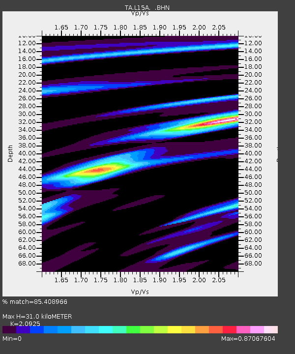
| Estimated Moho Depth: |
31.0 km |
| Estimated Crust Vp/Vs: |
2.09 |
| Assumed Crust Vp: |
6.279 km/s |
| Estimated Crust Vs: |
3.001 km/s |
| Estimated Crust Poisson's Ratio: |
0.35 |
|
| Radial Match: |
85.408966 % |
| Radial Bump: |
383 |
| Transverse Match: |
73.486435 % |
| Transverse Bump: |
400 |
| SOD ConfigId: |
2658 |
| Insert Time: |
2010-03-06 13:29:56.072 +0000 |
| GWidth: |
2.5 |
| Max Bumps: |
400 |
| Tol: |
0.001 |
|

Signal To Noise
| Channel | StoN | STA | LTA |
| TA:L15A: :BHN:20081107T07:32:13.624001Z | 4.426132 | 2.8026267E-7 | 6.3319995E-8 |
| TA:L15A: :BHE:20081107T07:32:13.624001Z | 1.8545537 | 1.0215747E-7 | 5.5084662E-8 |
| TA:L15A: :BHZ:20081107T07:32:13.624001Z | 1.188297 | 1.2051576E-7 | 1.01418884E-7 |
| Arrivals |
| Ps | 5.5 SECOND |
| PpPs | 15 SECOND |
| PsPs/PpSs | 21 SECOND |


