You are here: Home > Network List > TA - USArray Transportable Network (new EarthScope stations) Stations List
> Station L15A Malad City, ID, USA > Earthquake Result Viewer
L15A Malad City, ID, USA - Earthquake Result Viewer
| Earthquake location: |
Central East Pacific Rise |
| Earthquake latitude/longitude: |
-4.6/-106.0 |
| Earthquake time(UTC): |
2008/09/18 (262) 01:41:02 GMT |
| Earthquake Depth: |
10 km |
| Earthquake Magnitude: |
5.5 MB, 5.7 MS, 6.0 MW, 6.0 MW |
| Earthquake Catalog/Contributor: |
WHDF/NEIC |
|
| Network: |
TA USArray Transportable Network (new EarthScope stations) |
| Station: |
L15A Malad City, ID, USA |
| Lat/Lon: |
42.00 N/112.39 W |
| Elevation: |
1646 m |
|
| Distance: |
46.7 deg |
| Az: |
353.459 deg |
| Baz: |
171.237 deg |
| Ray Param: |
0.07048049 |
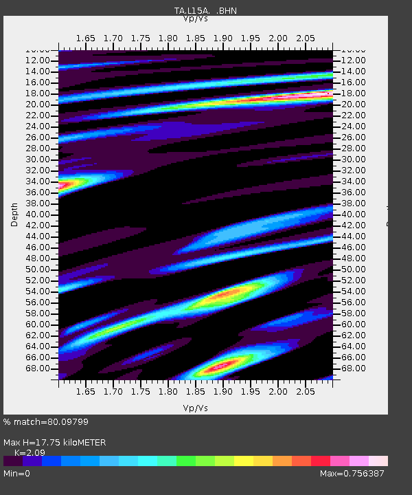
| Estimated Moho Depth: |
17.75 km |
| Estimated Crust Vp/Vs: |
2.09 |
| Assumed Crust Vp: |
6.279 km/s |
| Estimated Crust Vs: |
3.004 km/s |
| Estimated Crust Poisson's Ratio: |
0.35 |
|
| Radial Match: |
80.09799 % |
| Radial Bump: |
400 |
| Transverse Match: |
79.54314 % |
| Transverse Bump: |
400 |
| SOD ConfigId: |
2560 |
| Insert Time: |
2010-03-06 13:30:03.886 +0000 |
| GWidth: |
2.5 |
| Max Bumps: |
400 |
| Tol: |
0.001 |
|

Signal To Noise
| Channel | StoN | STA | LTA |
| TA:L15A: :BHN:20080918T01:49:00.824009Z | 4.8509064 | 3.3005756E-7 | 6.8040386E-8 |
| TA:L15A: :BHE:20080918T01:49:00.824009Z | 2.5590644 | 1.6000521E-7 | 6.252489E-8 |
| TA:L15A: :BHZ:20080918T01:49:00.824009Z | 0.9654513 | 5.0400526E-8 | 5.220411E-8 |
| Arrivals |
| Ps | 3.2 SECOND |
| PpPs | 8.3 SECOND |
| PsPs/PpSs | 12 SECOND |


