You are here: Home > Network List > TA - USArray Transportable Network (new EarthScope stations) Stations List
> Station L15A Malad City, ID, USA > Earthquake Result Viewer
L15A Malad City, ID, USA - Earthquake Result Viewer
| Earthquake location: |
Andreanof Islands, Aleutian Is. |
| Earthquake latitude/longitude: |
52.2/-178.7 |
| Earthquake time(UTC): |
2008/03/22 (082) 21:24:11 GMT |
| Earthquake Depth: |
132 km |
| Earthquake Magnitude: |
5.8 MB, 6.2 MW, 6.1 MW |
| Earthquake Catalog/Contributor: |
WHDF/NEIC |
|
| Network: |
TA USArray Transportable Network (new EarthScope stations) |
| Station: |
L15A Malad City, ID, USA |
| Lat/Lon: |
42.00 N/112.39 W |
| Elevation: |
1646 m |
|
| Distance: |
44.8 deg |
| Az: |
75.637 deg |
| Baz: |
306.832 deg |
| Ray Param: |
0.0712082 |
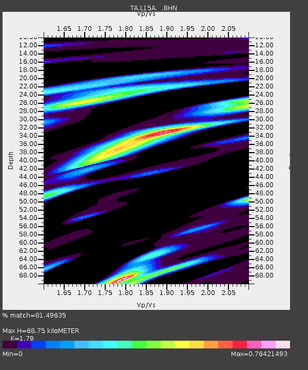
| Estimated Moho Depth: |
68.75 km |
| Estimated Crust Vp/Vs: |
1.79 |
| Assumed Crust Vp: |
6.279 km/s |
| Estimated Crust Vs: |
3.508 km/s |
| Estimated Crust Poisson's Ratio: |
0.27 |
|
| Radial Match: |
81.49635 % |
| Radial Bump: |
385 |
| Transverse Match: |
76.76922 % |
| Transverse Bump: |
400 |
| SOD ConfigId: |
2564 |
| Insert Time: |
2010-03-06 13:30:08.786 +0000 |
| GWidth: |
2.5 |
| Max Bumps: |
400 |
| Tol: |
0.001 |
|

Signal To Noise
| Channel | StoN | STA | LTA |
| TA:L15A: :BHN:20080322T21:31:41.448009Z | 4.451654 | 5.525098E-7 | 1.2411337E-7 |
| TA:L15A: :BHE:20080322T21:31:41.448009Z | 6.3322296 | 6.519116E-7 | 1.0295135E-7 |
| TA:L15A: :BHZ:20080322T21:31:41.448009Z | 15.41094 | 1.7578877E-6 | 1.1406752E-7 |
| Arrivals |
| Ps | 9.2 SECOND |
| PpPs | 29 SECOND |
| PsPs/PpSs | 38 SECOND |


