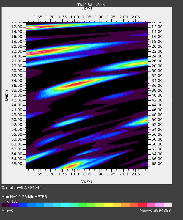
L15A Malad City, ID, USA - Earthquake Result Viewer
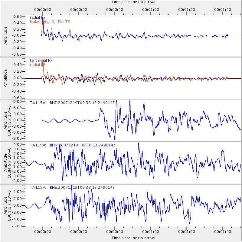
Earthquake location: Andreanof Islands, Aleutian Is.
Earthquake latitude/longitude: 51.4/-179.5
Earthquake time(UTC): 2007/12/19 (353) 09:30:27 GMT
Earthquake Depth: 29 km
Earthquake Magnitude: 6.4 MB, 7.1 MS, 7.1 MW, 7.0 MW
Earthquake Catalog/Contributor: WHDF/NEIC
Network: TA USArray Transportable Network (new EarthScope stations)
Station: L15A Malad City, ID, USA
Lat/Lon: 42.00 N/112.39 W
Elevation: 1646 m
Distance: 45.5 deg
Az: 74.352 deg
Baz: 305.905 deg
Ray Param: 0.071183495
Estimated Moho Depth: 12.25 km
Estimated Crust Vp/Vs: 1.60
Assumed Crust Vp: 6.279 km/s
Estimated Crust Vs: 3.924 km/s
Estimated Crust Poisson's Ratio: 0.18
Radial Match: 92.794044 %
Radial Bump: 400
Transverse Match: 73.29113 %
Transverse Bump: 400
SOD ConfigId: 2564
Insert Time: 2010-03-06 13:30:24.555 +0000
GWidth: 2.5
Max Bumps: 400
Tol: 0.001

Signal To Noise

ChannelStoNSTALTA
TA:L15A: :BHN:20071219T09:38:13.249014Z3.0857687.753087E-72.5125308E-7
TA:L15A: :BHE:20071219T09:38:13.249014Z3.34259061.4884653E-64.453029E-7
TA:L15A: :BHZ:20071219T09:38:13.249014Z6.16910653.203511E-65.192828E-7
Arrivals
Ps1.3 SECOND
PpPs4.7 SECOND
PsPs/PpSs6.0 SECOND