You are here: Home > Network List > TA - USArray Transportable Network (new EarthScope stations) Stations List
> Station L15A Malad City, ID, USA > Earthquake Result Viewer
L15A Malad City, ID, USA - Earthquake Result Viewer
| Earthquake location: |
South Of Mariana Islands |
| Earthquake latitude/longitude: |
10.5/145.7 |
| Earthquake time(UTC): |
2007/09/30 (273) 02:08:30 GMT |
| Earthquake Depth: |
14 km |
| Earthquake Magnitude: |
6.4 MB, 7.1 MS, 6.9 MW, 6.9 MW |
| Earthquake Catalog/Contributor: |
WHDF/NEIC |
|
| Network: |
TA USArray Transportable Network (new EarthScope stations) |
| Station: |
L15A Malad City, ID, USA |
| Lat/Lon: |
42.00 N/112.39 W |
| Elevation: |
1646 m |
|
| Distance: |
91.8 deg |
| Az: |
46.859 deg |
| Baz: |
285.645 deg |
| Ray Param: |
0.04155765 |
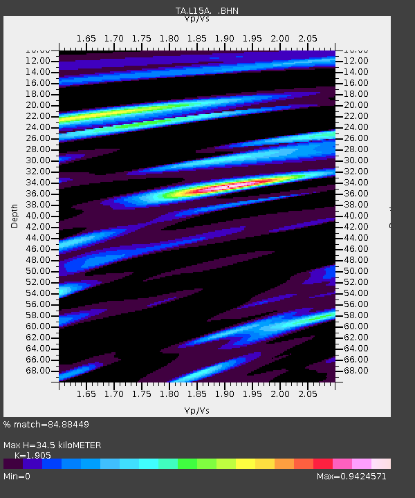
| Estimated Moho Depth: |
34.5 km |
| Estimated Crust Vp/Vs: |
1.90 |
| Assumed Crust Vp: |
6.279 km/s |
| Estimated Crust Vs: |
3.296 km/s |
| Estimated Crust Poisson's Ratio: |
0.31 |
|
| Radial Match: |
84.88449 % |
| Radial Bump: |
400 |
| Transverse Match: |
84.805695 % |
| Transverse Bump: |
400 |
| SOD ConfigId: |
2564 |
| Insert Time: |
2010-03-06 13:30:44.420 +0000 |
| GWidth: |
2.5 |
| Max Bumps: |
400 |
| Tol: |
0.001 |
|
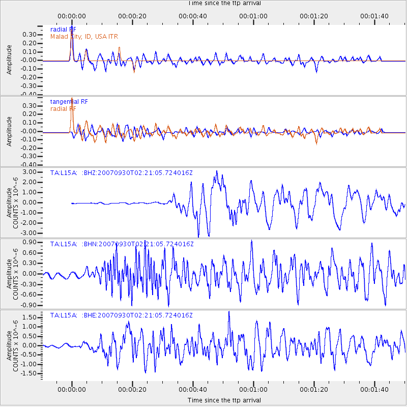
Signal To Noise
| Channel | StoN | STA | LTA |
| TA:L15A: :BHN:20070930T02:21:05.724016Z | 1.0528536 | 7.9139156E-8 | 7.516634E-8 |
| TA:L15A: :BHE:20070930T02:21:05.724016Z | 1.6789486 | 9.8509155E-8 | 5.8673123E-8 |
| TA:L15A: :BHZ:20070930T02:21:05.724016Z | 7.022992 | 3.246912E-7 | 4.6232604E-8 |
| Arrivals |
| Ps | 5.1 SECOND |
| PpPs | 16 SECOND |
| PsPs/PpSs | 21 SECOND |


