You are here: Home > Network List > TA - USArray Transportable Network (new EarthScope stations) Stations List
> Station D20K Etivluk River, AK, USA > Earthquake Result Viewer
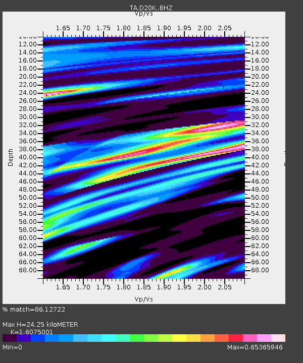
D20K Etivluk River, AK, USA - Earthquake Result Viewer
| Earthquake location: |
Off East Coast Of Honshu, Japan |
| Earthquake latitude/longitude: |
37.9/144.1 |
| Earthquake time(UTC): |
2018/08/07 (219) 15:12:57 GMT |
| Earthquake Depth: |
12 km |
| Earthquake Magnitude: |
5.6 Mww |
| Earthquake Catalog/Contributor: |
NEIC PDE/us |
|
| Network: |
TA USArray Transportable Network (new EarthScope stations) |
| Station: |
D20K Etivluk River, AK, USA |
| Lat/Lon: |
68.71 N/156.61 W |
| Elevation: |
577 m |
|
| Distance: |
44.2 deg |
| Az: |
26.762 deg |
| Baz: |
257.365 deg |
| Ray Param: |
0.07204197 |
| Estimated Moho Depth: |
24.25 km |
| Estimated Crust Vp/Vs: |
1.61 |
| Assumed Crust Vp: |
6.221 km/s |
| Estimated Crust Vs: |
3.87 km/s |
| Estimated Crust Poisson's Ratio: |
0.18 |
|
| Radial Match: |
86.12722 % |
| Radial Bump: |
400 |
| Transverse Match: |
76.02291 % |
| Transverse Bump: |
400 |
| SOD ConfigId: |
13570011 |
| Insert Time: |
2019-04-30 17:52:21.081 +0000 |
| GWidth: |
2.5 |
| Max Bumps: |
400 |
| Tol: |
0.001 |
|

Signal To Noise
| Channel | StoN | STA | LTA |
| TA:D20K: :BHZ:20180807T15:20:35.250013Z | 13.65933 | 1.0423022E-6 | 7.6306975E-8 |
| TA:D20K: :BHN:20180807T15:20:35.250013Z | 1.6655104 | 1.3260846E-7 | 7.9620314E-8 |
| TA:D20K: :BHE:20180807T15:20:35.250013Z | 7.609915 | 4.2412995E-7 | 5.573386E-8 |
| Arrivals |
| Ps | 2.5 SECOND |
| PpPs | 9.5 SECOND |
| PsPs/PpSs | 12 SECOND |


