You are here: Home > Network List > CI - Caltech Regional Seismic Network Stations List
> Station PHL Parkhill, California, USA > Earthquake Result Viewer
PHL Parkhill, California, USA - Earthquake Result Viewer

| Earthquake location: |
Jujuy Province, Argentina |
| Earthquake latitude/longitude: |
-22.6/-66.3 |
| Earthquake time(UTC): |
2007/11/18 (322) 05:40:12 GMT |
| Earthquake Depth: |
246 km |
| Earthquake Magnitude: |
5.7 MB, 6.0 MW, 6.0 MW |
| Earthquake Catalog/Contributor: |
WHDF/NEIC |
|
| Network: |
CI Caltech Regional Seismic Network |
| Station: |
PHL Parkhill, California, USA |
| Lat/Lon: |
35.41 N/120.55 W |
| Elevation: |
351 m |
|
| Distance: |
77.3 deg |
| Az: |
317.2 deg |
| Baz: |
129.79 deg |
| Ray Param: |
0.049783856 |
| Estimated Moho Depth: |
24.5 km |
| Estimated Crust Vp/Vs: |
1.72 |
| Assumed Crust Vp: |
6.183 km/s |
| Estimated Crust Vs: |
3.589 km/s |
| Estimated Crust Poisson's Ratio: |
0.25 |
|
| Radial Match: |
83.639984 % |
| Radial Bump: |
400 |
| Transverse Match: |
75.04768 % |
| Transverse Bump: |
400 |
| SOD ConfigId: |
2564 |
| Insert Time: |
2010-02-26 02:08:38.117 +0000 |
| GWidth: |
2.5 |
| Max Bumps: |
400 |
| Tol: |
0.001 |
|
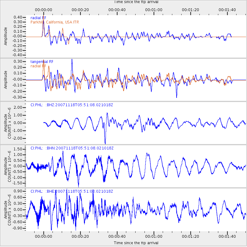
Signal To Noise
| Channel | StoN | STA | LTA |
| CI:PHL: :BHN:20071118T05:51:08.021018Z | 1.2148715 | 2.5752144E-7 | 2.119742E-7 |
| CI:PHL: :BHE:20071118T05:51:08.021018Z | 1.8519365 | 3.7406596E-7 | 2.0198638E-7 |
| CI:PHL: :BHZ:20071118T05:51:08.021018Z | 2.38932 | 9.917472E-7 | 4.1507514E-7 |
| Arrivals |
| Ps | 2.9 SECOND |
| PpPs | 10 SECOND |
| PsPs/PpSs | 13 SECOND |


