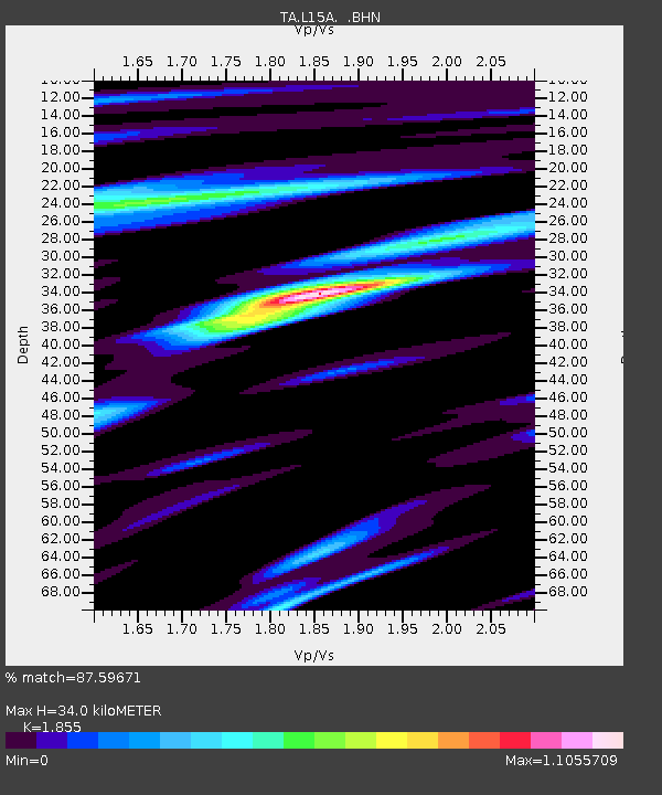
L15A Malad City, ID, USA - Earthquake Result Viewer
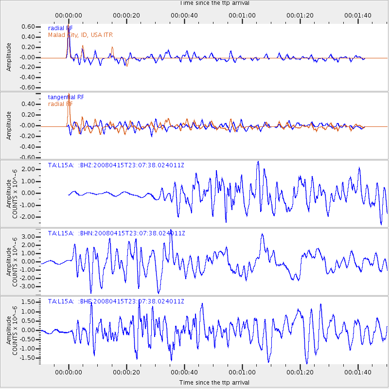
Earthquake location: Andreanof Islands, Aleutian Is.
Earthquake latitude/longitude: 51.9/-179.4
Earthquake time(UTC): 2008/04/15 (106) 22:59:51 GMT
Earthquake Depth: 10 km
Earthquake Magnitude: 6.1 MB, 6.4 MS, 6.4 MW, 6.4 MW
Earthquake Catalog/Contributor: WHDF/NEIC
Network: TA USArray Transportable Network (new EarthScope stations)
Station: L15A Malad City, ID, USA
Lat/Lon: 42.00 N/112.39 W
Elevation: 1646 m
Distance: 45.3 deg
Az: 74.921 deg
Baz: 306.533 deg
Ray Param: 0.07139102
Estimated Moho Depth: 34.0 km
Estimated Crust Vp/Vs: 1.86
Assumed Crust Vp: 6.279 km/s
Estimated Crust Vs: 3.385 km/s
Estimated Crust Poisson's Ratio: 0.30
Radial Match: 87.59671 %
Radial Bump: 400
Transverse Match: 82.43526 %
Transverse Bump: 400
SOD ConfigId: 2504
Insert Time: 2010-03-06 13:31:14.639 +0000
GWidth: 2.5
Max Bumps: 400
Tol: 0.001

Signal To Noise

ChannelStoNSTALTA
TA:L15A: :BHN:20080415T23:07:38.024011Z7.8776969.4253636E-71.1964619E-7
TA:L15A: :BHE:20080415T23:07:38.024011Z2.29873923.3403765E-71.4531341E-7
TA:L15A: :BHZ:20080415T23:07:38.024011Z3.10139633.5803842E-71.15444266E-7
Arrivals
Ps4.9 SECOND
PpPs15 SECOND
PsPs/PpSs19 SECOND