You are here: Home > Network List > TA - USArray Transportable Network (new EarthScope stations) Stations List
> Station G31M Satah River, YT, CAN > Earthquake Result Viewer
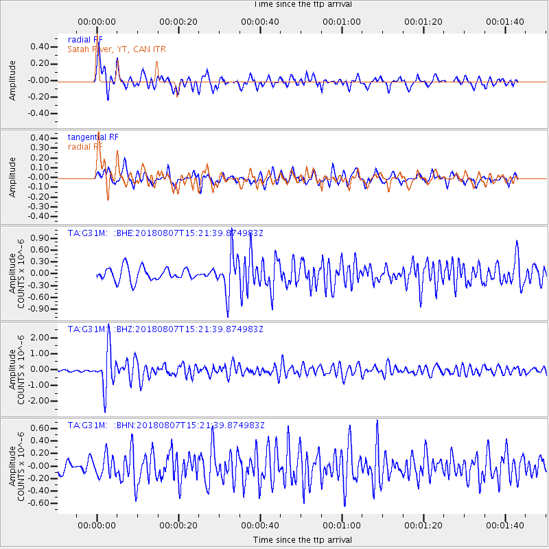
G31M Satah River, YT, CAN - Earthquake Result Viewer
*The percent match for this event was below the threshold and hence no stack was calculated.
| Earthquake location: |
Off East Coast Of Honshu, Japan |
| Earthquake latitude/longitude: |
37.9/144.1 |
| Earthquake time(UTC): |
2018/08/07 (219) 15:12:57 GMT |
| Earthquake Depth: |
12 km |
| Earthquake Magnitude: |
5.6 Mww |
| Earthquake Catalog/Contributor: |
NEIC PDE/us |
|
| Network: |
TA USArray Transportable Network (new EarthScope stations) |
| Station: |
G31M Satah River, YT, CAN |
| Lat/Lon: |
66.92 N/134.27 W |
| Elevation: |
61 m |
|
| Distance: |
52.6 deg |
| Az: |
29.397 deg |
| Baz: |
279.828 deg |
| Ray Param: |
$rayparam |
*The percent match for this event was below the threshold and hence was not used in the summary stack. |
|
| Radial Match: |
76.389206 % |
| Radial Bump: |
400 |
| Transverse Match: |
72.418526 % |
| Transverse Bump: |
400 |
| SOD ConfigId: |
13570011 |
| Insert Time: |
2019-04-30 17:52:57.334 +0000 |
| GWidth: |
2.5 |
| Max Bumps: |
400 |
| Tol: |
0.001 |
|
Signal To Noise
| Channel | StoN | STA | LTA |
| TA:G31M: :BHZ:20180807T15:21:39.874983Z | 15.131615 | 1.2425575E-6 | 8.211664E-8 |
| TA:G31M: :BHN:20180807T15:21:39.874983Z | 1.6871233 | 1.6157459E-7 | 9.576928E-8 |
| TA:G31M: :BHE:20180807T15:21:39.874983Z | 3.0151377 | 4.9323387E-7 | 1.6358585E-7 |
| Arrivals |
| Ps | |
| PpPs | |
| PsPs/PpSs | |


