You are here: Home > Network List > TA - USArray Transportable Network (new EarthScope stations) Stations List
> Station I17K Unalakleet, AK, USA > Earthquake Result Viewer
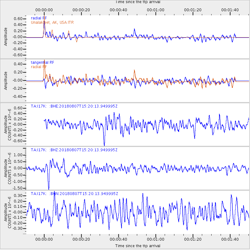
I17K Unalakleet, AK, USA - Earthquake Result Viewer
*The percent match for this event was below the threshold and hence no stack was calculated.
| Earthquake location: |
Off East Coast Of Honshu, Japan |
| Earthquake latitude/longitude: |
37.9/144.1 |
| Earthquake time(UTC): |
2018/08/07 (219) 15:12:57 GMT |
| Earthquake Depth: |
12 km |
| Earthquake Magnitude: |
5.6 Mww |
| Earthquake Catalog/Contributor: |
NEIC PDE/us |
|
| Network: |
TA USArray Transportable Network (new EarthScope stations) |
| Station: |
I17K Unalakleet, AK, USA |
| Lat/Lon: |
63.89 N/160.70 W |
| Elevation: |
105 m |
|
| Distance: |
41.6 deg |
| Az: |
33.212 deg |
| Baz: |
258.356 deg |
| Ray Param: |
$rayparam |
*The percent match for this event was below the threshold and hence was not used in the summary stack. |
|
| Radial Match: |
69.01803 % |
| Radial Bump: |
400 |
| Transverse Match: |
57.028088 % |
| Transverse Bump: |
400 |
| SOD ConfigId: |
13570011 |
| Insert Time: |
2019-04-30 17:53:08.228 +0000 |
| GWidth: |
2.5 |
| Max Bumps: |
400 |
| Tol: |
0.001 |
|
Signal To Noise
| Channel | StoN | STA | LTA |
| TA:I17K: :BHZ:20180807T15:20:13.949995Z | 5.837353 | 5.812202E-7 | 9.956914E-8 |
| TA:I17K: :BHN:20180807T15:20:13.949995Z | 1.4464155 | 1.6249234E-7 | 1.123414E-7 |
| TA:I17K: :BHE:20180807T15:20:13.949995Z | 2.505351 | 2.7177018E-7 | 1.0847589E-7 |
| Arrivals |
| Ps | |
| PpPs | |
| PsPs/PpSs | |


