You are here: Home > Network List > TA - USArray Transportable Network (new EarthScope stations) Stations List
> Station I23K Minto, Yukon-Koyukuk, AK, USA > Earthquake Result Viewer
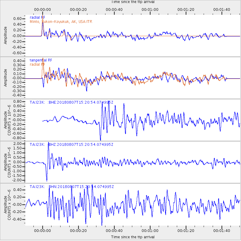
I23K Minto, Yukon-Koyukuk, AK, USA - Earthquake Result Viewer
*The percent match for this event was below the threshold and hence no stack was calculated.
| Earthquake location: |
Off East Coast Of Honshu, Japan |
| Earthquake latitude/longitude: |
37.9/144.1 |
| Earthquake time(UTC): |
2018/08/07 (219) 15:12:57 GMT |
| Earthquake Depth: |
12 km |
| Earthquake Magnitude: |
5.6 Mww |
| Earthquake Catalog/Contributor: |
NEIC PDE/us |
|
| Network: |
TA USArray Transportable Network (new EarthScope stations) |
| Station: |
I23K Minto, Yukon-Koyukuk, AK, USA |
| Lat/Lon: |
65.15 N/149.36 W |
| Elevation: |
149 m |
|
| Distance: |
46.6 deg |
| Az: |
32.255 deg |
| Baz: |
267.894 deg |
| Ray Param: |
$rayparam |
*The percent match for this event was below the threshold and hence was not used in the summary stack. |
|
| Radial Match: |
69.61478 % |
| Radial Bump: |
400 |
| Transverse Match: |
61.902466 % |
| Transverse Bump: |
400 |
| SOD ConfigId: |
13570011 |
| Insert Time: |
2019-04-30 17:53:09.930 +0000 |
| GWidth: |
2.5 |
| Max Bumps: |
400 |
| Tol: |
0.001 |
|
Signal To Noise
| Channel | StoN | STA | LTA |
| TA:I23K: :BHZ:20180807T15:20:54.074995Z | 7.902423 | 8.8519704E-7 | 1.12015904E-7 |
| TA:I23K: :BHN:20180807T15:20:54.074995Z | 2.3287623 | 1.7643421E-7 | 7.576309E-8 |
| TA:I23K: :BHE:20180807T15:20:54.074995Z | 4.871919 | 3.873492E-7 | 7.950649E-8 |
| Arrivals |
| Ps | |
| PpPs | |
| PsPs/PpSs | |


