You are here: Home > Network List > TA - USArray Transportable Network (new EarthScope stations) Stations List
> Station L15A Malad City, ID, USA > Earthquake Result Viewer
L15A Malad City, ID, USA - Earthquake Result Viewer
| Earthquake location: |
Solomon Islands |
| Earthquake latitude/longitude: |
-10.5/161.3 |
| Earthquake time(UTC): |
2008/06/03 (155) 16:20:50 GMT |
| Earthquake Depth: |
84 km |
| Earthquake Magnitude: |
6.2 MB, 6.2 MW, 6.2 MW |
| Earthquake Catalog/Contributor: |
WHDF/NEIC |
|
| Network: |
TA USArray Transportable Network (new EarthScope stations) |
| Station: |
L15A Malad City, ID, USA |
| Lat/Lon: |
42.00 N/112.39 W |
| Elevation: |
1646 m |
|
| Distance: |
94.2 deg |
| Az: |
48.233 deg |
| Baz: |
259.782 deg |
| Ray Param: |
0.04103771 |
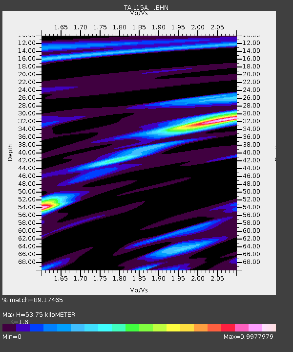
| Estimated Moho Depth: |
53.75 km |
| Estimated Crust Vp/Vs: |
1.60 |
| Assumed Crust Vp: |
6.279 km/s |
| Estimated Crust Vs: |
3.924 km/s |
| Estimated Crust Poisson's Ratio: |
0.18 |
|
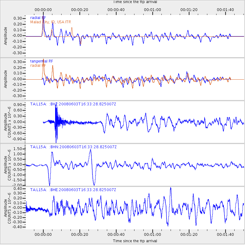
| Radial Match: |
89.17465 % |
| Radial Bump: |
400 |
| Transverse Match: |
86.85152 % |
| Transverse Bump: |
400 |
| SOD ConfigId: |
2504 |
| Insert Time: |
2010-03-06 13:31:27.195 +0000 |
| GWidth: |
2.5 |
| Max Bumps: |
400 |
| Tol: |
0.001 |
|
Signal To Noise
| Channel | StoN | STA | LTA |
| TA:L15A: :BHN:20080603T16:33:28.825007Z | 8.805679 | 7.756498E-7 | 8.808517E-8 |
| TA:L15A: :BHE:20080603T16:33:28.825007Z | 0.45338395 | 8.7137224E-8 | 1.92193E-7 |
| TA:L15A: :BHZ:20080603T16:33:28.825007Z | 1.4491814 | 2.2759997E-7 | 1.5705415E-7 |
| Arrivals |
| Ps | 5.2 SECOND |
| PpPs | 22 SECOND |
| PsPs/PpSs | 27 SECOND |


