You are here: Home > Network List > TA - USArray Transportable Network (new EarthScope stations) Stations List
> Station K29M Barlow Dome, YT, CAN > Earthquake Result Viewer
K29M Barlow Dome, YT, CAN - Earthquake Result Viewer

| Earthquake location: |
Off East Coast Of Honshu, Japan |
| Earthquake latitude/longitude: |
37.9/144.1 |
| Earthquake time(UTC): |
2018/08/07 (219) 15:12:57 GMT |
| Earthquake Depth: |
12 km |
| Earthquake Magnitude: |
5.6 Mww |
| Earthquake Catalog/Contributor: |
NEIC PDE/us |
|
| Network: |
TA USArray Transportable Network (new EarthScope stations) |
| Station: |
K29M Barlow Dome, YT, CAN |
| Lat/Lon: |
63.84 N/137.52 W |
| Elevation: |
1367 m |
|
| Distance: |
51.8 deg |
| Az: |
33.542 deg |
| Baz: |
279.417 deg |
| Ray Param: |
0.06717433 |
| Estimated Moho Depth: |
22.5 km |
| Estimated Crust Vp/Vs: |
1.88 |
| Assumed Crust Vp: |
6.566 km/s |
| Estimated Crust Vs: |
3.488 km/s |
| Estimated Crust Poisson's Ratio: |
0.30 |
|
| Radial Match: |
89.855705 % |
| Radial Bump: |
380 |
| Transverse Match: |
72.39848 % |
| Transverse Bump: |
400 |
| SOD ConfigId: |
13570011 |
| Insert Time: |
2019-04-30 17:53:27.861 +0000 |
| GWidth: |
2.5 |
| Max Bumps: |
400 |
| Tol: |
0.001 |
|
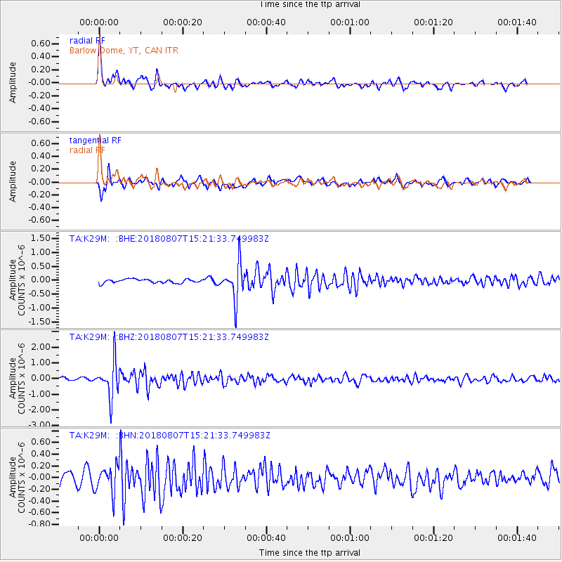
Signal To Noise
| Channel | StoN | STA | LTA |
| TA:K29M: :BHZ:20180807T15:21:33.749983Z | 13.355973 | 1.144677E-6 | 8.570524E-8 |
| TA:K29M: :BHN:20180807T15:21:33.749983Z | 3.31612 | 2.2484052E-7 | 6.780229E-8 |
| TA:K29M: :BHE:20180807T15:21:33.749983Z | 9.643929 | 6.53374E-7 | 6.7749774E-8 |
| Arrivals |
| Ps | 3.2 SECOND |
| PpPs | 9.3 SECOND |
| PsPs/PpSs | 13 SECOND |


