You are here: Home > Network List > TA - USArray Transportable Network (new EarthScope stations) Stations List
> Station L15A Malad City, ID, USA > Earthquake Result Viewer
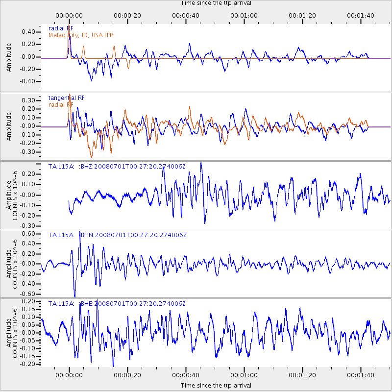
L15A Malad City, ID, USA - Earthquake Result Viewer
*The percent match for this event was below the threshold and hence no stack was calculated.
| Earthquake location: |
Central Peru |
| Earthquake latitude/longitude: |
-10.4/-75.5 |
| Earthquake time(UTC): |
2008/07/01 (183) 00:17:33 GMT |
| Earthquake Depth: |
33 km |
| Earthquake Magnitude: |
5.5 MW, 5.0 MS, 5.4 MB, 5.3 ML |
| Earthquake Catalog/Contributor: |
WHDF/NEIC |
|
| Network: |
TA USArray Transportable Network (new EarthScope stations) |
| Station: |
L15A Malad City, ID, USA |
| Lat/Lon: |
42.00 N/112.39 W |
| Elevation: |
1646 m |
|
| Distance: |
62.1 deg |
| Az: |
329.609 deg |
| Baz: |
138.1 deg |
| Ray Param: |
$rayparam |
*The percent match for this event was below the threshold and hence was not used in the summary stack. |
|
| Radial Match: |
55.531734 % |
| Radial Bump: |
400 |
| Transverse Match: |
72.53008 % |
| Transverse Bump: |
400 |
| SOD ConfigId: |
2504 |
| Insert Time: |
2010-03-06 13:31:56.981 +0000 |
| GWidth: |
2.5 |
| Max Bumps: |
400 |
| Tol: |
0.001 |
|
Signal To Noise
| Channel | StoN | STA | LTA |
| TA:L15A: :BHN:20080701T00:27:20.274006Z | 5.051871 | 2.8641387E-7 | 5.6694617E-8 |
| TA:L15A: :BHE:20080701T00:27:20.274006Z | 2.122755 | 9.177058E-8 | 4.3231825E-8 |
| TA:L15A: :BHZ:20080701T00:27:20.274006Z | 2.5733588 | 1.1969655E-7 | 4.6513748E-8 |
| Arrivals |
| Ps | |
| PpPs | |
| PsPs/PpSs | |


