You are here: Home > Network List > TA - USArray Transportable Network (new EarthScope stations) Stations List
> Station L15A Malad City, ID, USA > Earthquake Result Viewer
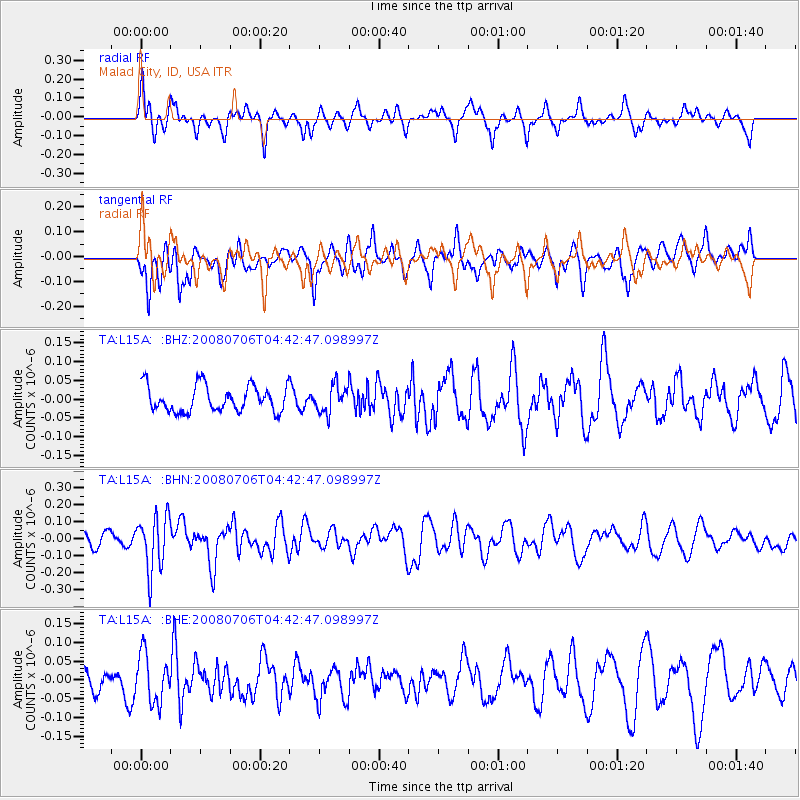
L15A Malad City, ID, USA - Earthquake Result Viewer
*The percent match for this event was below the threshold and hence no stack was calculated.
| Earthquake location: |
South Of Fiji Islands |
| Earthquake latitude/longitude: |
-25.5/-176.4 |
| Earthquake time(UTC): |
2008/07/06 (188) 04:30:26 GMT |
| Earthquake Depth: |
49 km |
| Earthquake Magnitude: |
5.5 MB, 5.3 MS |
| Earthquake Catalog/Contributor: |
WHDF/NEIC |
|
| Network: |
TA USArray Transportable Network (new EarthScope stations) |
| Station: |
L15A Malad City, ID, USA |
| Lat/Lon: |
42.00 N/112.39 W |
| Elevation: |
1646 m |
|
| Distance: |
89.4 deg |
| Az: |
42.047 deg |
| Baz: |
234.323 deg |
| Ray Param: |
$rayparam |
*The percent match for this event was below the threshold and hence was not used in the summary stack. |
|
| Radial Match: |
45.220863 % |
| Radial Bump: |
322 |
| Transverse Match: |
62.406063 % |
| Transverse Bump: |
400 |
| SOD ConfigId: |
2504 |
| Insert Time: |
2010-03-06 13:31:58.203 +0000 |
| GWidth: |
2.5 |
| Max Bumps: |
400 |
| Tol: |
0.001 |
|
Signal To Noise
| Channel | StoN | STA | LTA |
| TA:L15A: :BHN:20080706T04:42:47.098997Z | 2.5976527 | 1.613254E-7 | 6.2104306E-8 |
| TA:L15A: :BHE:20080706T04:42:47.098997Z | 1.122401 | 6.4053715E-8 | 5.7068473E-8 |
| TA:L15A: :BHZ:20080706T04:42:47.098997Z | 1.0631198 | 3.6772963E-8 | 3.458967E-8 |
| Arrivals |
| Ps | |
| PpPs | |
| PsPs/PpSs | |


