You are here: Home > Network List > UW - Pacific Northwest Regional Seismic Network Stations List
> Station LEBA Lebam, WA, USA > Earthquake Result Viewer
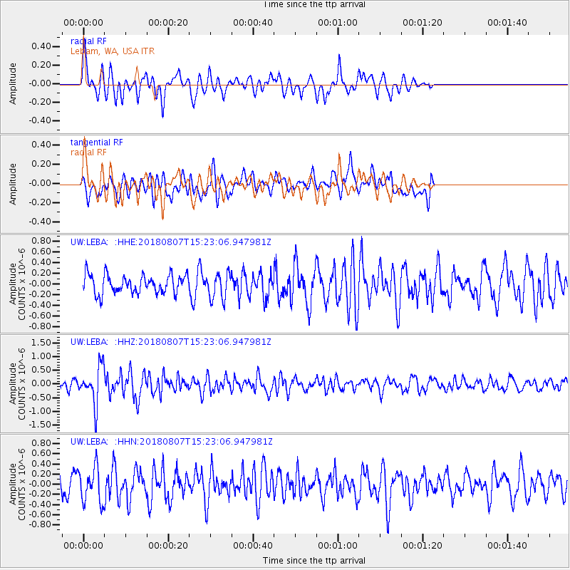
LEBA Lebam, WA, USA - Earthquake Result Viewer
*The percent match for this event was below the threshold and hence no stack was calculated.
| Earthquake location: |
Off East Coast Of Honshu, Japan |
| Earthquake latitude/longitude: |
37.9/144.1 |
| Earthquake time(UTC): |
2018/08/07 (219) 15:12:57 GMT |
| Earthquake Depth: |
12 km |
| Earthquake Magnitude: |
5.6 Mww |
| Earthquake Catalog/Contributor: |
NEIC PDE/us |
|
| Network: |
UW Pacific Northwest Regional Seismic Network |
| Station: |
LEBA Lebam, WA, USA |
| Lat/Lon: |
46.55 N/123.56 W |
| Elevation: |
73 m |
|
| Distance: |
65.2 deg |
| Az: |
49.447 deg |
| Baz: |
299.412 deg |
| Ray Param: |
$rayparam |
*The percent match for this event was below the threshold and hence was not used in the summary stack. |
|
| Radial Match: |
66.42378 % |
| Radial Bump: |
400 |
| Transverse Match: |
50.51332 % |
| Transverse Bump: |
400 |
| SOD ConfigId: |
13570011 |
| Insert Time: |
2019-04-30 17:55:31.088 +0000 |
| GWidth: |
2.5 |
| Max Bumps: |
400 |
| Tol: |
0.001 |
|
Signal To Noise
| Channel | StoN | STA | LTA |
| UW:LEBA: :HHZ:20180807T15:23:06.947981Z | 4.3859463 | 6.945117E-7 | 1.5834934E-7 |
| UW:LEBA: :HHN:20180807T15:23:06.947981Z | 2.2667935 | 3.467021E-7 | 1.5294826E-7 |
| UW:LEBA: :HHE:20180807T15:23:06.947981Z | 1.4263107 | 2.4226503E-7 | 1.6985433E-7 |
| Arrivals |
| Ps | |
| PpPs | |
| PsPs/PpSs | |


