You are here: Home > Network List > TA - USArray Transportable Network (new EarthScope stations) Stations List
> Station L15A Malad City, ID, USA > Earthquake Result Viewer
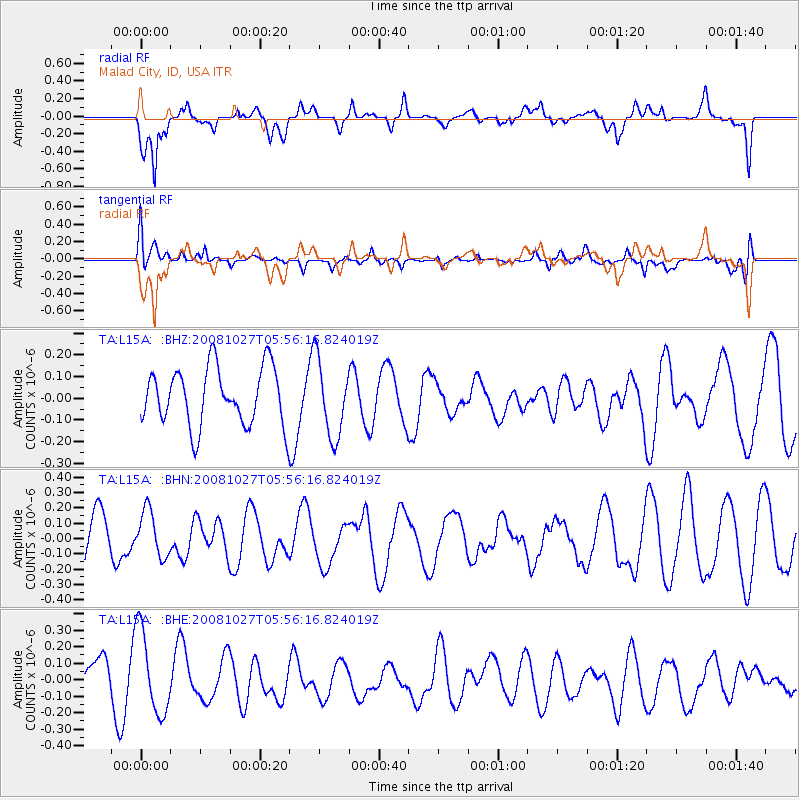
L15A Malad City, ID, USA - Earthquake Result Viewer
*The percent match for this event was below the threshold and hence no stack was calculated.
| Earthquake location: |
Vanuatu Islands |
| Earthquake latitude/longitude: |
-14.6/167.2 |
| Earthquake time(UTC): |
2008/10/27 (301) 05:43:50 GMT |
| Earthquake Depth: |
129 km |
| Earthquake Magnitude: |
5.6 MW, 5.2 MB, 5.6 MW |
| Earthquake Catalog/Contributor: |
WHDF/NEIC |
|
| Network: |
TA USArray Transportable Network (new EarthScope stations) |
| Station: |
L15A Malad City, ID, USA |
| Lat/Lon: |
42.00 N/112.39 W |
| Elevation: |
1646 m |
|
| Distance: |
92.7 deg |
| Az: |
47.374 deg |
| Baz: |
252.858 deg |
| Ray Param: |
$rayparam |
*The percent match for this event was below the threshold and hence was not used in the summary stack. |
|
| Radial Match: |
73.45254 % |
| Radial Bump: |
400 |
| Transverse Match: |
37.42615 % |
| Transverse Bump: |
400 |
| SOD ConfigId: |
2560 |
| Insert Time: |
2010-03-06 13:33:14.823 +0000 |
| GWidth: |
2.5 |
| Max Bumps: |
400 |
| Tol: |
0.001 |
|
Signal To Noise
| Channel | StoN | STA | LTA |
| TA:L15A: :BHN:20081027T05:56:16.824019Z | 1.1143086 | 1.4931696E-7 | 1.3399965E-7 |
| TA:L15A: :BHE:20081027T05:56:16.824019Z | 2.3740568 | 2.5103387E-7 | 1.0574046E-7 |
| TA:L15A: :BHZ:20081027T05:56:16.824019Z | 1.3165148 | 1.7527303E-7 | 1.3313411E-7 |
| Arrivals |
| Ps | |
| PpPs | |
| PsPs/PpSs | |


