You are here: Home > Network List > TA - USArray Transportable Network (new EarthScope stations) Stations List
> Station G18A Lazy EL Ranch, Roscoe, MT, USA > Earthquake Result Viewer
G18A Lazy EL Ranch, Roscoe, MT, USA - Earthquake Result Viewer
| Earthquake location: |
North Of Honduras |
| Earthquake latitude/longitude: |
16.7/-86.2 |
| Earthquake time(UTC): |
2009/05/28 (148) 08:24:45 GMT |
| Earthquake Depth: |
10 km |
| Earthquake Magnitude: |
6.7 MB, 7.2 MS, 7.3 MW, 7.3 MW |
| Earthquake Catalog/Contributor: |
WHDF/NEIC |
|
| Network: |
TA USArray Transportable Network (new EarthScope stations) |
| Station: |
G18A Lazy EL Ranch, Roscoe, MT, USA |
| Lat/Lon: |
45.32 N/109.56 W |
| Elevation: |
1699 m |
|
| Distance: |
34.6 deg |
| Az: |
330.497 deg |
| Baz: |
138.022 deg |
| Ray Param: |
0.077674314 |
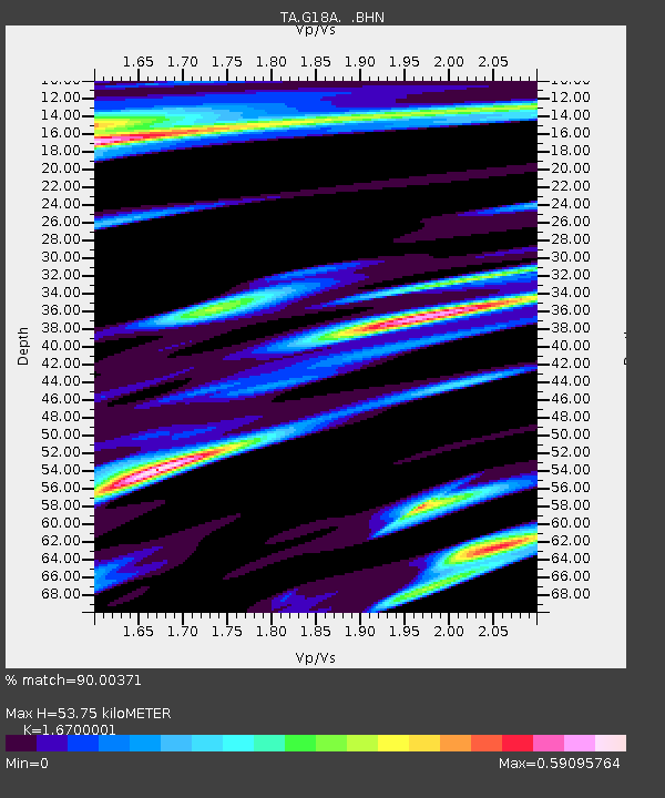
| Estimated Moho Depth: |
53.75 km |
| Estimated Crust Vp/Vs: |
1.67 |
| Assumed Crust Vp: |
6.242 km/s |
| Estimated Crust Vs: |
3.738 km/s |
| Estimated Crust Poisson's Ratio: |
0.22 |
|
| Radial Match: |
90.00371 % |
| Radial Bump: |
400 |
| Transverse Match: |
85.11244 % |
| Transverse Bump: |
380 |
| SOD ConfigId: |
2648 |
| Insert Time: |
2010-03-06 13:33:39.164 +0000 |
| GWidth: |
2.5 |
| Max Bumps: |
400 |
| Tol: |
0.001 |
|

Signal To Noise
| Channel | StoN | STA | LTA |
| TA:G18A: :BHN:20090528T08:31:03.050001Z | 21.083866 | 1.278524E-6 | 6.063992E-8 |
| TA:G18A: :BHE:20090528T08:31:03.050001Z | 6.0917535 | 4.6455082E-7 | 7.6258964E-8 |
| TA:G18A: :BHZ:20090528T08:31:03.050001Z | 8.170451 | 6.516025E-7 | 7.97511E-8 |
| Arrivals |
| Ps | 6.2 SECOND |
| PpPs | 21 SECOND |
| PsPs/PpSs | 28 SECOND |


