You are here: Home > Network List > TA - USArray Transportable Network (new EarthScope stations) Stations List
> Station D25K Kavik River, AK, USA > Earthquake Result Viewer
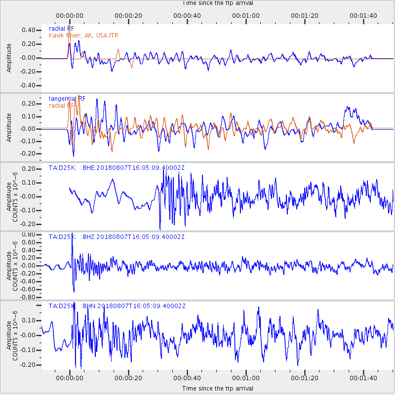
D25K Kavik River, AK, USA - Earthquake Result Viewer
*The percent match for this event was below the threshold and hence no stack was calculated.
| Earthquake location: |
Northern Colombia |
| Earthquake latitude/longitude: |
6.8/-73.0 |
| Earthquake time(UTC): |
2018/08/07 (219) 15:53:59 GMT |
| Earthquake Depth: |
148 km |
| Earthquake Magnitude: |
5.6 mb |
| Earthquake Catalog/Contributor: |
NEIC PDE/us |
|
| Network: |
TA USArray Transportable Network (new EarthScope stations) |
| Station: |
D25K Kavik River, AK, USA |
| Lat/Lon: |
69.32 N/146.38 W |
| Elevation: |
770 m |
|
| Distance: |
77.8 deg |
| Az: |
339.625 deg |
| Baz: |
103.236 deg |
| Ray Param: |
$rayparam |
*The percent match for this event was below the threshold and hence was not used in the summary stack. |
|
| Radial Match: |
54.044582 % |
| Radial Bump: |
400 |
| Transverse Match: |
52.75119 % |
| Transverse Bump: |
400 |
| SOD ConfigId: |
13570011 |
| Insert Time: |
2019-04-30 18:05:25.512 +0000 |
| GWidth: |
2.5 |
| Max Bumps: |
400 |
| Tol: |
0.001 |
|
Signal To Noise
| Channel | StoN | STA | LTA |
| TA:D25K: :BHZ:20180807T16:05:09.40002Z | 3.67867 | 2.6967442E-7 | 7.330758E-8 |
| TA:D25K: :BHN:20180807T16:05:09.40002Z | 2.964961 | 1.0036277E-7 | 3.384961E-8 |
| TA:D25K: :BHE:20180807T16:05:09.40002Z | 1.9819796 | 1.0323088E-7 | 5.2084733E-8 |
| Arrivals |
| Ps | |
| PpPs | |
| PsPs/PpSs | |


