You are here: Home > Network List > TA - USArray Transportable Network (new EarthScope stations) Stations List
> Station MSTX Muleshoe, TX, USA > Earthquake Result Viewer
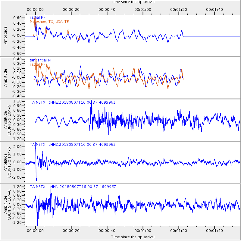
MSTX Muleshoe, TX, USA - Earthquake Result Viewer
*The percent match for this event was below the threshold and hence no stack was calculated.
| Earthquake location: |
Northern Colombia |
| Earthquake latitude/longitude: |
6.8/-73.0 |
| Earthquake time(UTC): |
2018/08/07 (219) 15:53:59 GMT |
| Earthquake Depth: |
148 km |
| Earthquake Magnitude: |
5.6 mb |
| Earthquake Catalog/Contributor: |
NEIC PDE/us |
|
| Network: |
TA USArray Transportable Network (new EarthScope stations) |
| Station: |
MSTX Muleshoe, TX, USA |
| Lat/Lon: |
33.97 N/102.77 W |
| Elevation: |
1167 m |
|
| Distance: |
38.6 deg |
| Az: |
318.568 deg |
| Baz: |
127.746 deg |
| Ray Param: |
$rayparam |
*The percent match for this event was below the threshold and hence was not used in the summary stack. |
|
| Radial Match: |
56.690964 % |
| Radial Bump: |
360 |
| Transverse Match: |
49.08518 % |
| Transverse Bump: |
400 |
| SOD ConfigId: |
13570011 |
| Insert Time: |
2019-04-30 18:06:27.735 +0000 |
| GWidth: |
2.5 |
| Max Bumps: |
400 |
| Tol: |
0.001 |
|
Signal To Noise
| Channel | StoN | STA | LTA |
| TA:MSTX: :HHZ:20180807T16:00:37.469996Z | 6.0677233 | 9.0740076E-7 | 1.495455E-7 |
| TA:MSTX: :HHN:20180807T16:00:37.469996Z | 4.4278703 | 4.1952404E-7 | 9.474624E-8 |
| TA:MSTX: :HHE:20180807T16:00:37.469996Z | 2.0419755 | 3.6304343E-7 | 1.7779028E-7 |
| Arrivals |
| Ps | |
| PpPs | |
| PsPs/PpSs | |


