You are here: Home > Network List > CI - Caltech Regional Seismic Network Stations List
> Station PHL Parkhill, California, USA > Earthquake Result Viewer
PHL Parkhill, California, USA - Earthquake Result Viewer
| Earthquake location: |
Solomon Islands |
| Earthquake latitude/longitude: |
-7.5/156.1 |
| Earthquake time(UTC): |
2007/04/01 (091) 22:57:23 GMT |
| Earthquake Depth: |
18 km |
| Earthquake Magnitude: |
5.7 MB |
| Earthquake Catalog/Contributor: |
WHDF/NEIC |
|
| Network: |
CI Caltech Regional Seismic Network |
| Station: |
PHL Parkhill, California, USA |
| Lat/Lon: |
35.41 N/120.55 W |
| Elevation: |
351 m |
|
| Distance: |
89.0 deg |
| Az: |
54.252 deg |
| Baz: |
260.088 deg |
| Ray Param: |
0.04217832 |
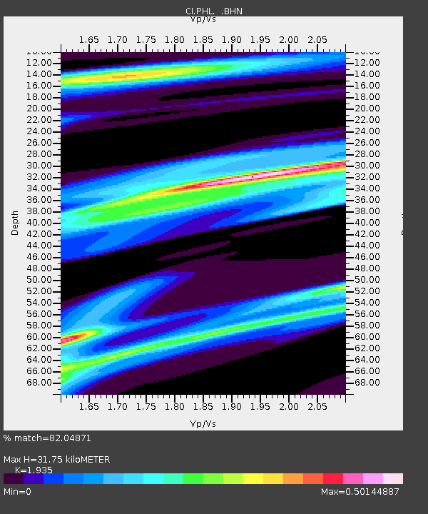
| Estimated Moho Depth: |
31.75 km |
| Estimated Crust Vp/Vs: |
1.93 |
| Assumed Crust Vp: |
6.183 km/s |
| Estimated Crust Vs: |
3.195 km/s |
| Estimated Crust Poisson's Ratio: |
0.32 |
|
| Radial Match: |
82.04871 % |
| Radial Bump: |
400 |
| Transverse Match: |
76.806305 % |
| Transverse Bump: |
400 |
| SOD ConfigId: |
2564 |
| Insert Time: |
2010-02-26 02:08:59.808 +0000 |
| GWidth: |
2.5 |
| Max Bumps: |
400 |
| Tol: |
0.001 |
|
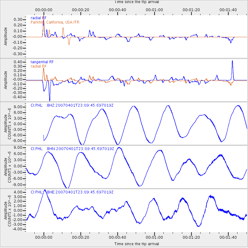
Signal To Noise
| Channel | StoN | STA | LTA |
| CI:PHL: :BHN:20070401T23:09:45.697019Z | 1.9629328 | 6.5523254E-6 | 3.3380281E-6 |
| CI:PHL: :BHE:20070401T23:09:45.697019Z | 2.3774555 | 3.6473348E-6 | 1.5341337E-6 |
| CI:PHL: :BHZ:20070401T23:09:45.697019Z | 1.3815747 | 7.687062E-6 | 5.5639853E-6 |
| Arrivals |
| Ps | 4.9 SECOND |
| PpPs | 15 SECOND |
| PsPs/PpSs | 20 SECOND |


