You are here: Home > Network List > TA - USArray Transportable Network (new EarthScope stations) Stations List
> Station P17K Kvichak River, AK, USA > Earthquake Result Viewer
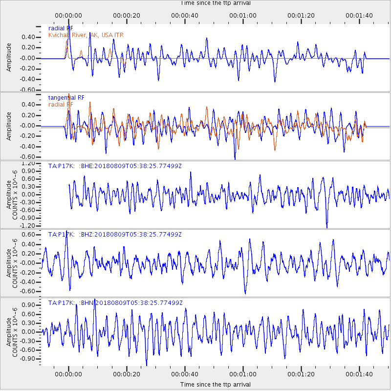
P17K Kvichak River, AK, USA - Earthquake Result Viewer
*The percent match for this event was below the threshold and hence no stack was calculated.
| Earthquake location: |
Sumbawa Region, Indonesia |
| Earthquake latitude/longitude: |
-8.4/116.2 |
| Earthquake time(UTC): |
2018/08/09 (221) 05:25:31 GMT |
| Earthquake Depth: |
10 km |
| Earthquake Magnitude: |
5.9 Mww |
| Earthquake Catalog/Contributor: |
NEIC PDE/us |
|
| Network: |
TA USArray Transportable Network (new EarthScope stations) |
| Station: |
P17K Kvichak River, AK, USA |
| Lat/Lon: |
59.20 N/156.44 W |
| Elevation: |
91 m |
|
| Distance: |
95.8 deg |
| Az: |
31.114 deg |
| Baz: |
263.431 deg |
| Ray Param: |
$rayparam |
*The percent match for this event was below the threshold and hence was not used in the summary stack. |
|
| Radial Match: |
54.23187 % |
| Radial Bump: |
400 |
| Transverse Match: |
47.951267 % |
| Transverse Bump: |
400 |
| SOD ConfigId: |
13570011 |
| Insert Time: |
2019-04-30 18:12:06.191 +0000 |
| GWidth: |
2.5 |
| Max Bumps: |
400 |
| Tol: |
0.001 |
|
Signal To Noise
| Channel | StoN | STA | LTA |
| TA:P17K: :BHZ:20180809T05:38:25.77499Z | 1.9354955 | 2.8880922E-7 | 1.492172E-7 |
| TA:P17K: :BHN:20180809T05:38:25.77499Z | 1.0758158 | 3.7701795E-7 | 3.5044843E-7 |
| TA:P17K: :BHE:20180809T05:38:25.77499Z | 0.96084446 | 2.9251024E-7 | 3.0443036E-7 |
| Arrivals |
| Ps | |
| PpPs | |
| PsPs/PpSs | |


