You are here: Home > Network List > TA - USArray Transportable Network (new EarthScope stations) Stations List
> Station G18A Lazy EL Ranch, Roscoe, MT, USA > Earthquake Result Viewer
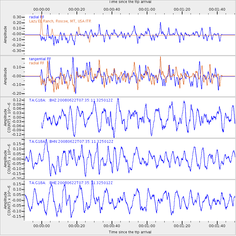
G18A Lazy EL Ranch, Roscoe, MT, USA - Earthquake Result Viewer
*The percent match for this event was below the threshold and hence no stack was calculated.
| Earthquake location: |
Solomon Islands |
| Earthquake latitude/longitude: |
-8.9/157.8 |
| Earthquake time(UTC): |
2008/06/22 (174) 07:22:06 GMT |
| Earthquake Depth: |
10 km |
| Earthquake Magnitude: |
5.5 MB, 5.5 MS, 5.8 MW, 5.7 MW |
| Earthquake Catalog/Contributor: |
WHDF/NEIC |
|
| Network: |
TA USArray Transportable Network (new EarthScope stations) |
| Station: |
G18A Lazy EL Ranch, Roscoe, MT, USA |
| Lat/Lon: |
45.32 N/109.56 W |
| Elevation: |
1699 m |
|
| Distance: |
98.1 deg |
| Az: |
45.388 deg |
| Baz: |
265.607 deg |
| Ray Param: |
$rayparam |
*The percent match for this event was below the threshold and hence was not used in the summary stack. |
|
| Radial Match: |
43.81926 % |
| Radial Bump: |
400 |
| Transverse Match: |
27.30942 % |
| Transverse Bump: |
333 |
| SOD ConfigId: |
2504 |
| Insert Time: |
2010-03-06 13:36:39.777 +0000 |
| GWidth: |
2.5 |
| Max Bumps: |
400 |
| Tol: |
0.001 |
|
Signal To Noise
| Channel | StoN | STA | LTA |
| TA:G18A: :BHN:20080622T07:35:11.325012Z | 2.2082036 | 9.9730066E-8 | 4.516344E-8 |
| TA:G18A: :BHE:20080622T07:35:11.325012Z | 1.3333412 | 6.557935E-8 | 4.918422E-8 |
| TA:G18A: :BHZ:20080622T07:35:11.325012Z | 1.5496659 | 7.152318E-8 | 4.6153936E-8 |
| Arrivals |
| Ps | |
| PpPs | |
| PsPs/PpSs | |


