You are here: Home > Network List > TA - USArray Transportable Network (new EarthScope stations) Stations List
> Station I17K Unalakleet, AK, USA > Earthquake Result Viewer
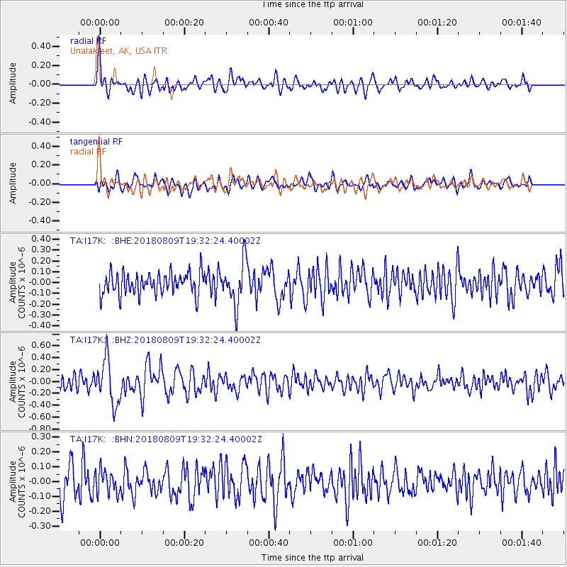
I17K Unalakleet, AK, USA - Earthquake Result Viewer
*The percent match for this event was below the threshold and hence no stack was calculated.
| Earthquake location: |
Near Coast Of Guatemala |
| Earthquake latitude/longitude: |
13.6/-91.2 |
| Earthquake time(UTC): |
2018/08/09 (221) 19:21:53 GMT |
| Earthquake Depth: |
29 km |
| Earthquake Magnitude: |
5.6 Mww |
| Earthquake Catalog/Contributor: |
NEIC PDE/us |
|
| Network: |
TA USArray Transportable Network (new EarthScope stations) |
| Station: |
I17K Unalakleet, AK, USA |
| Lat/Lon: |
63.89 N/160.70 W |
| Elevation: |
105 m |
|
| Distance: |
68.9 deg |
| Az: |
333.622 deg |
| Baz: |
102.503 deg |
| Ray Param: |
$rayparam |
*The percent match for this event was below the threshold and hence was not used in the summary stack. |
|
| Radial Match: |
61.13305 % |
| Radial Bump: |
400 |
| Transverse Match: |
52.67163 % |
| Transverse Bump: |
400 |
| SOD ConfigId: |
13570011 |
| Insert Time: |
2019-04-30 18:22:38.854 +0000 |
| GWidth: |
2.5 |
| Max Bumps: |
400 |
| Tol: |
0.001 |
|
Signal To Noise
| Channel | StoN | STA | LTA |
| TA:I17K: :BHZ:20180809T19:32:24.40002Z | 3.4701881 | 3.851861E-7 | 1.1099862E-7 |
| TA:I17K: :BHN:20180809T19:32:24.40002Z | 0.7052327 | 7.762731E-8 | 1.1007333E-7 |
| TA:I17K: :BHE:20180809T19:32:24.40002Z | 2.188027 | 2.1067358E-7 | 9.628472E-8 |
| Arrivals |
| Ps | |
| PpPs | |
| PsPs/PpSs | |


