You are here: Home > Network List > TA - USArray Transportable Network (new EarthScope stations) Stations List
> Station O18K Koktuh Hills, AK, USA > Earthquake Result Viewer
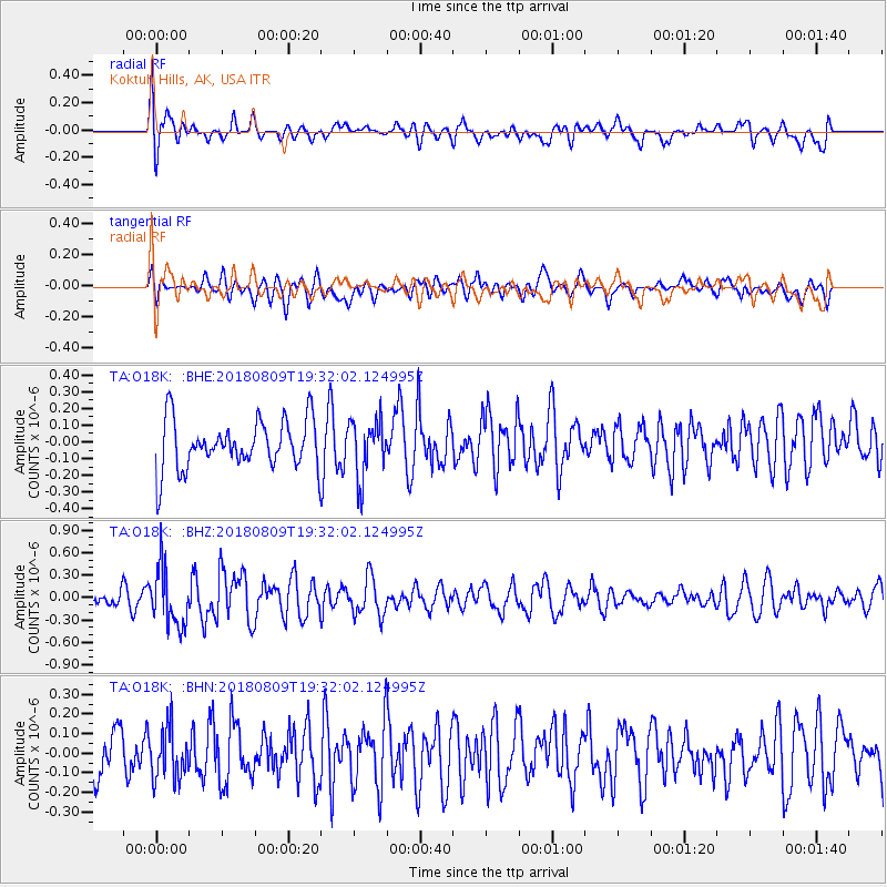
O18K Koktuh Hills, AK, USA - Earthquake Result Viewer
*The percent match for this event was below the threshold and hence no stack was calculated.
| Earthquake location: |
Near Coast Of Guatemala |
| Earthquake latitude/longitude: |
13.6/-91.2 |
| Earthquake time(UTC): |
2018/08/09 (221) 19:21:53 GMT |
| Earthquake Depth: |
29 km |
| Earthquake Magnitude: |
5.6 Mww |
| Earthquake Catalog/Contributor: |
NEIC PDE/us |
|
| Network: |
TA USArray Transportable Network (new EarthScope stations) |
| Station: |
O18K Koktuh Hills, AK, USA |
| Lat/Lon: |
59.85 N/155.21 W |
| Elevation: |
544 m |
|
| Distance: |
65.4 deg |
| Az: |
330.064 deg |
| Baz: |
105.956 deg |
| Ray Param: |
$rayparam |
*The percent match for this event was below the threshold and hence was not used in the summary stack. |
|
| Radial Match: |
59.91015 % |
| Radial Bump: |
400 |
| Transverse Match: |
47.580097 % |
| Transverse Bump: |
400 |
| SOD ConfigId: |
13570011 |
| Insert Time: |
2019-04-30 18:23:26.902 +0000 |
| GWidth: |
2.5 |
| Max Bumps: |
400 |
| Tol: |
0.001 |
|
Signal To Noise
| Channel | StoN | STA | LTA |
| TA:O18K: :BHZ:20180809T19:32:02.124995Z | 3.0457332 | 3.8820113E-7 | 1.2745737E-7 |
| TA:O18K: :BHN:20180809T19:32:02.124995Z | 1.2138455 | 1.2674718E-7 | 1.04417886E-7 |
| TA:O18K: :BHE:20180809T19:32:02.124995Z | 1.1519624 | 1.6555032E-7 | 1.4371156E-7 |
| Arrivals |
| Ps | |
| PpPs | |
| PsPs/PpSs | |


