You are here: Home > Network List > TA - USArray Transportable Network (new EarthScope stations) Stations List
> Station R32K Eaglecrest, AK, USA > Earthquake Result Viewer
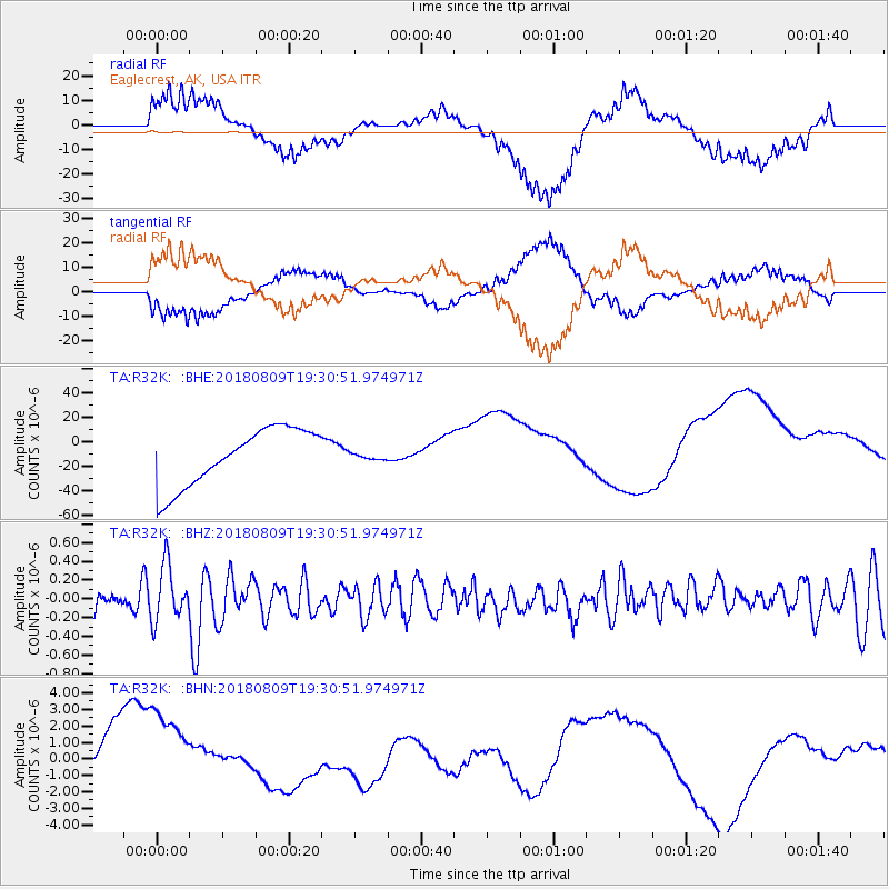
R32K Eaglecrest, AK, USA - Earthquake Result Viewer
*The percent match for this event was below the threshold and hence no stack was calculated.
| Earthquake location: |
Near Coast Of Guatemala |
| Earthquake latitude/longitude: |
13.6/-91.2 |
| Earthquake time(UTC): |
2018/08/09 (221) 19:21:53 GMT |
| Earthquake Depth: |
29 km |
| Earthquake Magnitude: |
5.6 Mww |
| Earthquake Catalog/Contributor: |
NEIC PDE/us |
|
| Network: |
TA USArray Transportable Network (new EarthScope stations) |
| Station: |
R32K Eaglecrest, AK, USA |
| Lat/Lon: |
58.27 N/134.52 W |
| Elevation: |
386 m |
|
| Distance: |
55.1 deg |
| Az: |
333.769 deg |
| Baz: |
125.57 deg |
| Ray Param: |
$rayparam |
*The percent match for this event was below the threshold and hence was not used in the summary stack. |
|
| Radial Match: |
35.50089 % |
| Radial Bump: |
392 |
| Transverse Match: |
34.231182 % |
| Transverse Bump: |
396 |
| SOD ConfigId: |
13570011 |
| Insert Time: |
2019-04-30 18:23:41.453 +0000 |
| GWidth: |
2.5 |
| Max Bumps: |
400 |
| Tol: |
0.001 |
|
Signal To Noise
| Channel | StoN | STA | LTA |
| TA:R32K: :BHZ:20180809T19:30:51.974971Z | 2.478719 | 2.9239223E-7 | 1.1796102E-7 |
| TA:R32K: :BHN:20180809T19:30:51.974971Z | 1.9788333 | 3.1934692E-6 | 1.6138142E-6 |
| TA:R32K: :BHE:20180809T19:30:51.974971Z | 0.15033333 | 3.3731499E-6 | 2.2437804E-5 |
| Arrivals |
| Ps | |
| PpPs | |
| PsPs/PpSs | |


