You are here: Home > Network List > CI - Caltech Regional Seismic Network Stations List
> Station PHL Parkhill, California, USA > Earthquake Result Viewer
PHL Parkhill, California, USA - Earthquake Result Viewer

| Earthquake location: |
Near Coast Of Chiapas, Mexico |
| Earthquake latitude/longitude: |
14.4/-92.4 |
| Earthquake time(UTC): |
2008/10/16 (290) 19:41:25 GMT |
| Earthquake Depth: |
24 km |
| Earthquake Magnitude: |
6.1 MB, 6.6 MS, 6.7 MW, 6.6 MW |
| Earthquake Catalog/Contributor: |
WHDF/NEIC |
|
| Network: |
CI Caltech Regional Seismic Network |
| Station: |
PHL Parkhill, California, USA |
| Lat/Lon: |
35.41 N/120.55 W |
| Elevation: |
351 m |
|
| Distance: |
32.8 deg |
| Az: |
314.616 deg |
| Baz: |
122.404 deg |
| Ray Param: |
0.078461744 |
| Estimated Moho Depth: |
24.25 km |
| Estimated Crust Vp/Vs: |
1.73 |
| Assumed Crust Vp: |
6.183 km/s |
| Estimated Crust Vs: |
3.569 km/s |
| Estimated Crust Poisson's Ratio: |
0.25 |
|
| Radial Match: |
94.47085 % |
| Radial Bump: |
396 |
| Transverse Match: |
87.890114 % |
| Transverse Bump: |
400 |
| SOD ConfigId: |
2560 |
| Insert Time: |
2010-02-26 02:09:20.146 +0000 |
| GWidth: |
2.5 |
| Max Bumps: |
400 |
| Tol: |
0.001 |
|
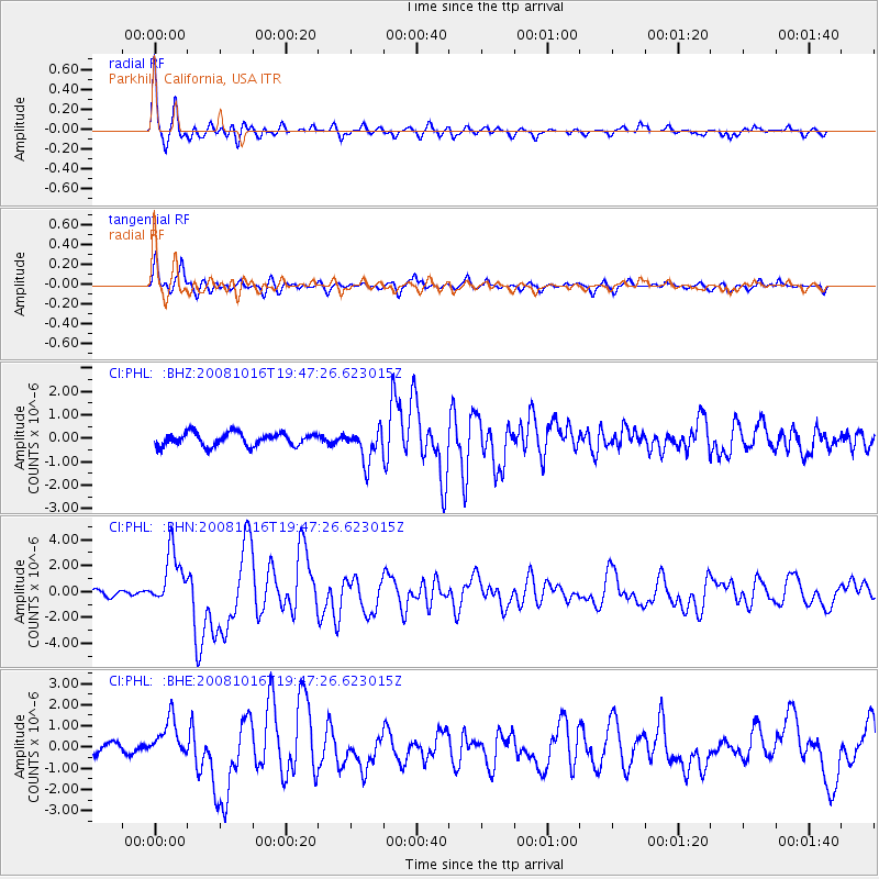
Signal To Noise
| Channel | StoN | STA | LTA |
| CI:PHL: :BHN:20081016T19:47:26.623015Z | 7.5559106 | 2.1369924E-6 | 2.8282398E-7 |
| CI:PHL: :BHE:20081016T19:47:26.623015Z | 4.35248 | 9.196623E-7 | 2.1129614E-7 |
| CI:PHL: :BHZ:20081016T19:47:26.623015Z | 2.5342803 | 6.93228E-7 | 2.735404E-7 |
| Arrivals |
| Ps | 3.1 SECOND |
| PpPs | 10.0 SECOND |
| PsPs/PpSs | 13 SECOND |


