You are here: Home > Network List > CI - Caltech Regional Seismic Network Stations List
> Station PHL Parkhill, California, USA > Earthquake Result Viewer
PHL Parkhill, California, USA - Earthquake Result Viewer
| Earthquake location: |
Tonga Islands |
| Earthquake latitude/longitude: |
-21.9/-173.8 |
| Earthquake time(UTC): |
2008/10/19 (293) 05:10:33 GMT |
| Earthquake Depth: |
29 km |
| Earthquake Magnitude: |
6.8 MB, 7.0 MS, 6.9 MW, 6.9 MW |
| Earthquake Catalog/Contributor: |
WHDF/NEIC |
|
| Network: |
CI Caltech Regional Seismic Network |
| Station: |
PHL Parkhill, California, USA |
| Lat/Lon: |
35.41 N/120.55 W |
| Elevation: |
351 m |
|
| Distance: |
76.1 deg |
| Az: |
42.413 deg |
| Baz: |
230.085 deg |
| Ray Param: |
0.051182806 |
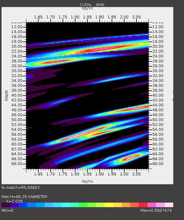
| Estimated Moho Depth: |
65.25 km |
| Estimated Crust Vp/Vs: |
2.03 |
| Assumed Crust Vp: |
6.183 km/s |
| Estimated Crust Vs: |
3.053 km/s |
| Estimated Crust Poisson's Ratio: |
0.34 |
|
| Radial Match: |
95.84683 % |
| Radial Bump: |
307 |
| Transverse Match: |
90.54986 % |
| Transverse Bump: |
400 |
| SOD ConfigId: |
2560 |
| Insert Time: |
2010-02-26 02:09:21.938 +0000 |
| GWidth: |
2.5 |
| Max Bumps: |
400 |
| Tol: |
0.001 |
|
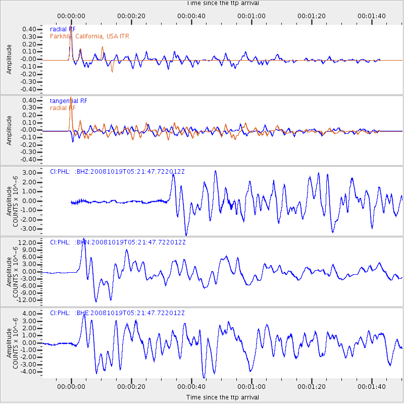
Signal To Noise
| Channel | StoN | STA | LTA |
| CI:PHL: :BHN:20081019T05:21:47.722012Z | 57.10937 | 6.2384574E-6 | 1.0923702E-7 |
| CI:PHL: :BHE:20081019T05:21:47.722012Z | 15.224809 | 1.7529509E-6 | 1.15137794E-7 |
| CI:PHL: :BHZ:20081019T05:21:47.722012Z | 13.729052 | 1.2147768E-6 | 8.848222E-8 |
| Arrivals |
| Ps | 11 SECOND |
| PpPs | 31 SECOND |
| PsPs/PpSs | 42 SECOND |


