You are here: Home > Network List > GT - Global Telemetered Seismograph Network (USAF/USGS) Stations List
> Station LPAZ La Paz , Bolivia > Earthquake Result Viewer
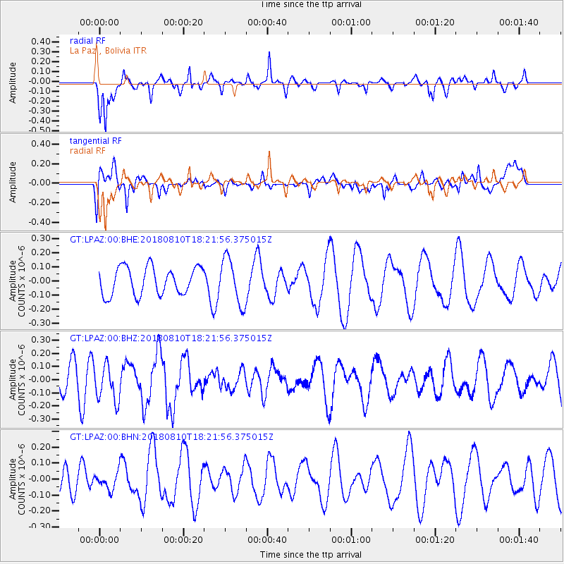
LPAZ La Paz , Bolivia - Earthquake Result Viewer
*The percent match for this event was below the threshold and hence no stack was calculated.
| Earthquake location: |
Balleny Islands Region |
| Earthquake latitude/longitude: |
-62.6/165.7 |
| Earthquake time(UTC): |
2018/08/10 (222) 18:09:24 GMT |
| Earthquake Depth: |
10 km |
| Earthquake Magnitude: |
5.6 Mww |
| Earthquake Catalog/Contributor: |
NEIC PDE/us |
|
| Network: |
GT Global Telemetered Seismograph Network (USAF/USGS) |
| Station: |
LPAZ La Paz , Bolivia |
| Lat/Lon: |
16.17 S/68.08 W |
| Elevation: |
4817 m |
|
| Distance: |
91.0 deg |
| Az: |
129.202 deg |
| Baz: |
201.882 deg |
| Ray Param: |
$rayparam |
*The percent match for this event was below the threshold and hence was not used in the summary stack. |
|
| Radial Match: |
57.896214 % |
| Radial Bump: |
372 |
| Transverse Match: |
43.2112 % |
| Transverse Bump: |
400 |
| SOD ConfigId: |
13570011 |
| Insert Time: |
2019-04-30 18:26:46.328 +0000 |
| GWidth: |
2.5 |
| Max Bumps: |
400 |
| Tol: |
0.001 |
|
Signal To Noise
| Channel | StoN | STA | LTA |
| GT:LPAZ:00:BHZ:20180810T18:21:56.375015Z | 1.422022 | 1.4181427E-7 | 9.97272E-8 |
| GT:LPAZ:00:BHN:20180810T18:21:56.375015Z | 0.54359466 | 5.4019235E-8 | 9.937411E-8 |
| GT:LPAZ:00:BHE:20180810T18:21:56.375015Z | 1.7421203 | 1.709565E-7 | 9.813129E-8 |
| Arrivals |
| Ps | |
| PpPs | |
| PsPs/PpSs | |


