You are here: Home > Network List > TA - USArray Transportable Network (new EarthScope stations) Stations List
> Station C11A Tepee Creek (NFS), Magee, ID, USA > Earthquake Result Viewer
C11A Tepee Creek (NFS), Magee, ID, USA - Earthquake Result Viewer
| Earthquake location: |
South Of Panama |
| Earthquake latitude/longitude: |
5.7/-82.8 |
| Earthquake time(UTC): |
2009/03/12 (071) 23:23:34 GMT |
| Earthquake Depth: |
9.0 km |
| Earthquake Magnitude: |
6.1 MB, 5.9 MS, 6.3 MW, 6.2 MW |
| Earthquake Catalog/Contributor: |
WHDF/NEIC |
|
| Network: |
TA USArray Transportable Network (new EarthScope stations) |
| Station: |
C11A Tepee Creek (NFS), Magee, ID, USA |
| Lat/Lon: |
47.84 N/116.26 W |
| Elevation: |
914 m |
|
| Distance: |
50.8 deg |
| Az: |
331.342 deg |
| Baz: |
134.893 deg |
| Ray Param: |
0.06780676 |
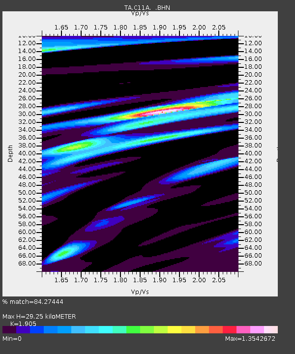
| Estimated Moho Depth: |
29.25 km |
| Estimated Crust Vp/Vs: |
1.90 |
| Assumed Crust Vp: |
6.571 km/s |
| Estimated Crust Vs: |
3.449 km/s |
| Estimated Crust Poisson's Ratio: |
0.31 |
|
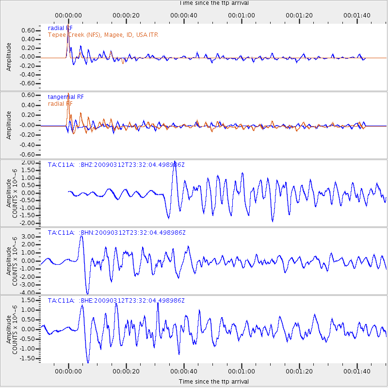
| Radial Match: |
84.27444 % |
| Radial Bump: |
400 |
| Transverse Match: |
68.08489 % |
| Transverse Bump: |
400 |
| SOD ConfigId: |
2658 |
| Insert Time: |
2010-03-06 13:38:34.522 +0000 |
| GWidth: |
2.5 |
| Max Bumps: |
400 |
| Tol: |
0.001 |
|
Signal To Noise
| Channel | StoN | STA | LTA |
| TA:C11A: :BHN:20090312T23:32:04.498986Z | 6.059535 | 1.3570296E-6 | 2.2394947E-7 |
| TA:C11A: :BHE:20090312T23:32:04.498986Z | 3.729085 | 4.862903E-7 | 1.3040471E-7 |
| TA:C11A: :BHZ:20090312T23:32:04.498986Z | 3.9811306 | 6.2240053E-7 | 1.5633765E-7 |
| Arrivals |
| Ps | 4.3 SECOND |
| PpPs | 12 SECOND |
| PsPs/PpSs | 16 SECOND |


