You are here: Home > Network List > AE - Arizona Broadband Seismic Network Stations List
> Station X18A Snowflake, AZ, USA > Earthquake Result Viewer
X18A Snowflake, AZ, USA - Earthquake Result Viewer
| Earthquake location: |
Kuril Islands |
| Earthquake latitude/longitude: |
48.5/154.8 |
| Earthquake time(UTC): |
2018/08/10 (222) 18:12:05 GMT |
| Earthquake Depth: |
16 km |
| Earthquake Magnitude: |
5.9 Mww |
| Earthquake Catalog/Contributor: |
NEIC PDE/us |
|
| Network: |
AE Arizona Broadband Seismic Network |
| Station: |
X18A Snowflake, AZ, USA |
| Lat/Lon: |
34.53 N/109.95 W |
| Elevation: |
1751 m |
|
| Distance: |
68.2 deg |
| Az: |
62.269 deg |
| Baz: |
314.48 deg |
| Ray Param: |
0.056417316 |
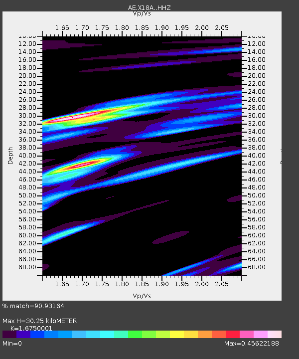
| Estimated Moho Depth: |
30.25 km |
| Estimated Crust Vp/Vs: |
1.68 |
| Assumed Crust Vp: |
6.496 km/s |
| Estimated Crust Vs: |
3.878 km/s |
| Estimated Crust Poisson's Ratio: |
0.22 |
|
| Radial Match: |
90.93164 % |
| Radial Bump: |
278 |
| Transverse Match: |
76.7972 % |
| Transverse Bump: |
400 |
| SOD ConfigId: |
13570011 |
| Insert Time: |
2019-04-30 18:28:14.861 +0000 |
| GWidth: |
2.5 |
| Max Bumps: |
400 |
| Tol: |
0.001 |
|

Signal To Noise
| Channel | StoN | STA | LTA |
| AE:X18A: :HHZ:20180810T18:22:33.720029Z | 12.828134 | 9.1816025E-7 | 7.157395E-8 |
| AE:X18A: :HHN:20180810T18:22:33.720029Z | 9.304478 | 3.2029362E-7 | 3.44236E-8 |
| AE:X18A: :HHE:20180810T18:22:33.720029Z | 4.015988 | 3.0658566E-7 | 7.634127E-8 |
| Arrivals |
| Ps | 3.3 SECOND |
| PpPs | 12 SECOND |
| PsPs/PpSs | 15 SECOND |


