You are here: Home > Network List > TA - USArray Transportable Network (new EarthScope stations) Stations List
> Station C11A Tepee Creek (NFS), Magee, ID, USA > Earthquake Result Viewer
C11A Tepee Creek (NFS), Magee, ID, USA - Earthquake Result Viewer
| Earthquake location: |
Peru-Ecuador Border Region |
| Earthquake latitude/longitude: |
-2.3/-77.8 |
| Earthquake time(UTC): |
2007/11/16 (320) 03:13:00 GMT |
| Earthquake Depth: |
123 km |
| Earthquake Magnitude: |
6.3 MB, 6.8 MW, 6.7 MW |
| Earthquake Catalog/Contributor: |
WHDF/NEIC |
|
| Network: |
TA USArray Transportable Network (new EarthScope stations) |
| Station: |
C11A Tepee Creek (NFS), Magee, ID, USA |
| Lat/Lon: |
47.84 N/116.26 W |
| Elevation: |
914 m |
|
| Distance: |
60.1 deg |
| Az: |
331.14 deg |
| Baz: |
134.284 deg |
| Ray Param: |
0.061358202 |
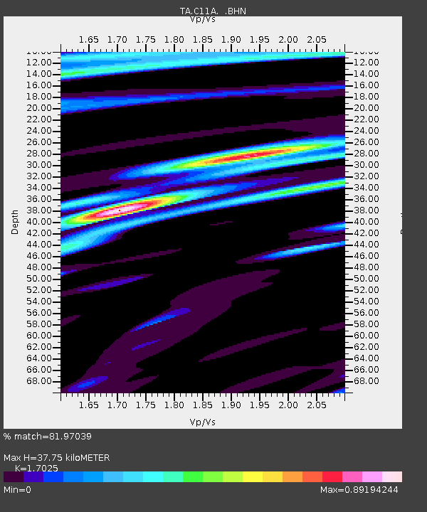
| Estimated Moho Depth: |
37.75 km |
| Estimated Crust Vp/Vs: |
1.70 |
| Assumed Crust Vp: |
6.571 km/s |
| Estimated Crust Vs: |
3.859 km/s |
| Estimated Crust Poisson's Ratio: |
0.24 |
|
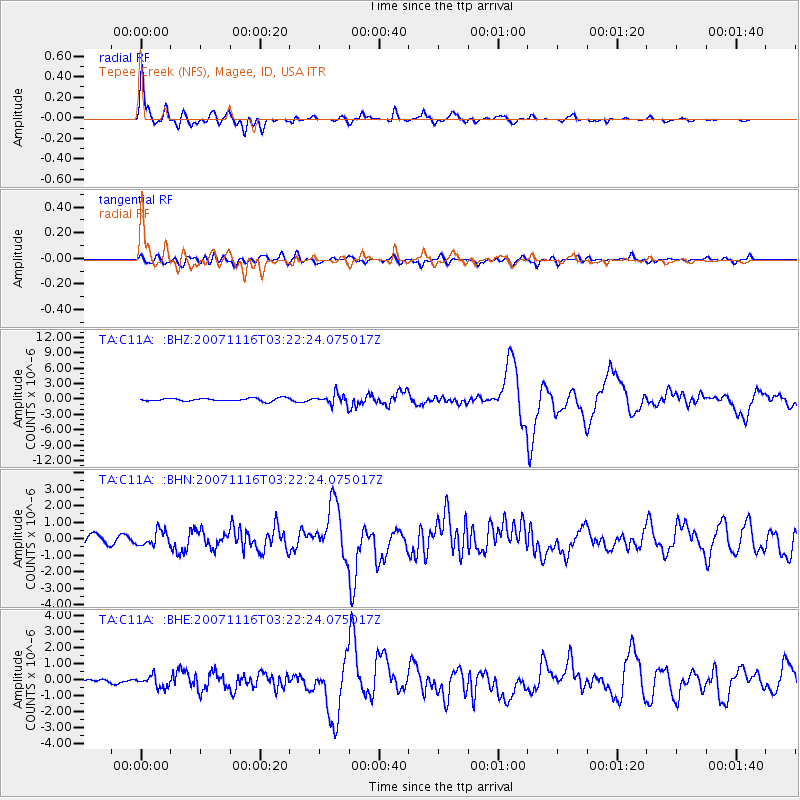
| Radial Match: |
81.97039 % |
| Radial Bump: |
400 |
| Transverse Match: |
72.137146 % |
| Transverse Bump: |
400 |
| SOD ConfigId: |
2564 |
| Insert Time: |
2010-03-06 13:38:43.626 +0000 |
| GWidth: |
2.5 |
| Max Bumps: |
400 |
| Tol: |
0.001 |
|
Signal To Noise
| Channel | StoN | STA | LTA |
| TA:C11A: :BHN:20071116T03:22:24.075017Z | 1.306021 | 4.5147937E-7 | 3.4569075E-7 |
| TA:C11A: :BHE:20071116T03:22:24.075017Z | 1.9742506 | 3.6052123E-7 | 1.826117E-7 |
| TA:C11A: :BHZ:20071116T03:22:24.075017Z | 3.591871 | 1.0271268E-6 | 2.8595872E-7 |
| Arrivals |
| Ps | 4.2 SECOND |
| PpPs | 15 SECOND |
| PsPs/PpSs | 19 SECOND |


