You are here: Home > Network List > AK - Alaska Regional Network Stations List
> Station SKN Skwentna > Earthquake Result Viewer
SKN Skwentna - Earthquake Result Viewer
| Earthquake location: |
Kuril Islands |
| Earthquake latitude/longitude: |
48.5/154.8 |
| Earthquake time(UTC): |
2018/08/10 (222) 18:12:05 GMT |
| Earthquake Depth: |
16 km |
| Earthquake Magnitude: |
5.9 Mww |
| Earthquake Catalog/Contributor: |
NEIC PDE/us |
|
| Network: |
AK Alaska Regional Network |
| Station: |
SKN Skwentna |
| Lat/Lon: |
61.98 N/151.53 W |
| Elevation: |
603 m |
|
| Distance: |
32.4 deg |
| Az: |
45.198 deg |
| Baz: |
270.551 deg |
| Ray Param: |
0.078641094 |
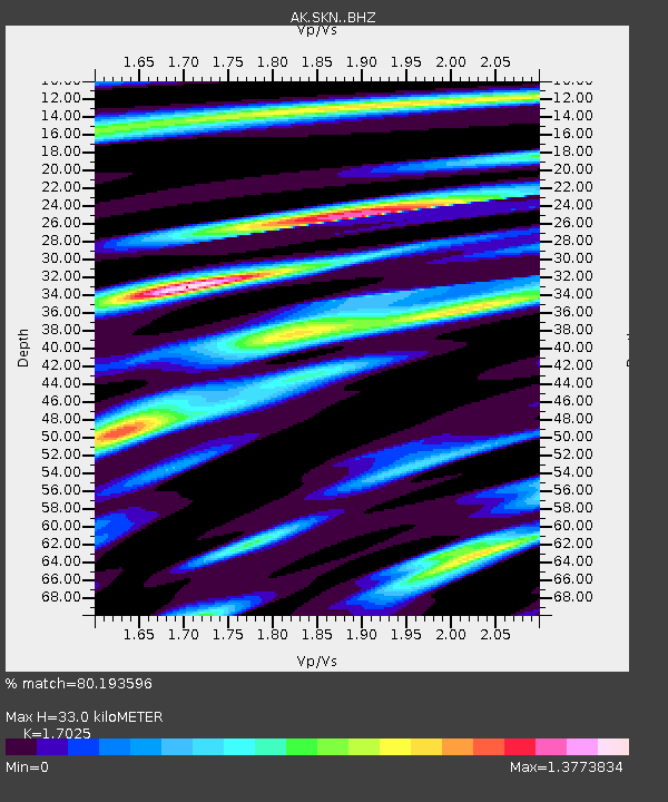
| Estimated Moho Depth: |
33.0 km |
| Estimated Crust Vp/Vs: |
1.70 |
| Assumed Crust Vp: |
6.302 km/s |
| Estimated Crust Vs: |
3.701 km/s |
| Estimated Crust Poisson's Ratio: |
0.24 |
|
| Radial Match: |
80.193596 % |
| Radial Bump: |
398 |
| Transverse Match: |
53.78497 % |
| Transverse Bump: |
400 |
| SOD ConfigId: |
13570011 |
| Insert Time: |
2019-04-30 18:29:08.177 +0000 |
| GWidth: |
2.5 |
| Max Bumps: |
400 |
| Tol: |
0.001 |
|

Signal To Noise
| Channel | StoN | STA | LTA |
| AK:SKN: :BHZ:20180810T18:18:03.787992Z | 10.676091 | 7.9001614E-7 | 7.399863E-8 |
| AK:SKN: :BHN:20180810T18:18:03.787992Z | 1.2087178 | 1.00496564E-7 | 8.3143114E-8 |
| AK:SKN: :BHE:20180810T18:18:03.787992Z | 3.4776223 | 3.632215E-7 | 1.0444535E-7 |
| Arrivals |
| Ps | 4.0 SECOND |
| PpPs | 13 SECOND |
| PsPs/PpSs | 17 SECOND |


