You are here: Home > Network List > TA - USArray Transportable Network (new EarthScope stations) Stations List
> Station C11A Tepee Creek (NFS), Magee, ID, USA > Earthquake Result Viewer
C11A Tepee Creek (NFS), Magee, ID, USA - Earthquake Result Viewer
| Earthquake location: |
Taiwan Region |
| Earthquake latitude/longitude: |
24.1/122.2 |
| Earthquake time(UTC): |
2009/07/13 (194) 18:05:01 GMT |
| Earthquake Depth: |
17 km |
| Earthquake Magnitude: |
6.1 MB, 6.3 MS, 6.3 MW, 6.2 MW |
| Earthquake Catalog/Contributor: |
WHDF/NEIC |
|
| Network: |
TA USArray Transportable Network (new EarthScope stations) |
| Station: |
C11A Tepee Creek (NFS), Magee, ID, USA |
| Lat/Lon: |
47.84 N/116.26 W |
| Elevation: |
914 m |
|
| Distance: |
91.3 deg |
| Az: |
35.05 deg |
| Baz: |
308.804 deg |
| Ray Param: |
0.04161106 |
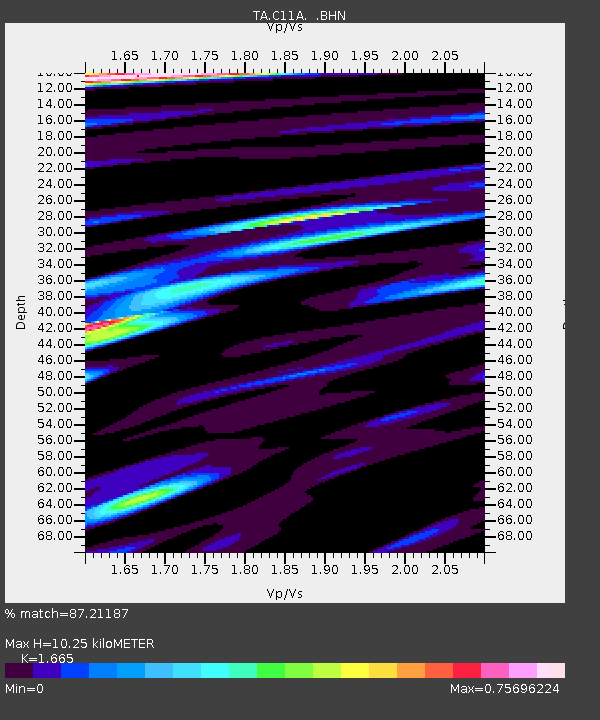
| Estimated Moho Depth: |
10.25 km |
| Estimated Crust Vp/Vs: |
1.66 |
| Assumed Crust Vp: |
6.571 km/s |
| Estimated Crust Vs: |
3.946 km/s |
| Estimated Crust Poisson's Ratio: |
0.22 |
|
| Radial Match: |
87.21187 % |
| Radial Bump: |
400 |
| Transverse Match: |
86.96044 % |
| Transverse Bump: |
400 |
| SOD ConfigId: |
2648 |
| Insert Time: |
2010-03-06 13:39:12.690 +0000 |
| GWidth: |
2.5 |
| Max Bumps: |
400 |
| Tol: |
0.001 |
|

Signal To Noise
| Channel | StoN | STA | LTA |
| TA:C11A: :BHN:20090713T18:17:34.325029Z | 9.755191 | 5.8857256E-7 | 6.0334294E-8 |
| TA:C11A: :BHE:20090713T18:17:34.325029Z | 5.349934 | 1.4031258E-7 | 2.6226974E-8 |
| TA:C11A: :BHZ:20090713T18:17:34.325029Z | 3.000526 | 1.4154497E-7 | 4.7173387E-8 |
| Arrivals |
| Ps | 1.1 SECOND |
| PpPs | 4.1 SECOND |
| PsPs/PpSs | 5.1 SECOND |


