You are here: Home > Network List > AV - Alaska Volcano Observatory Stations List
> Station PLK3 Mt. Peulik Volcano 3, Alaska > Earthquake Result Viewer
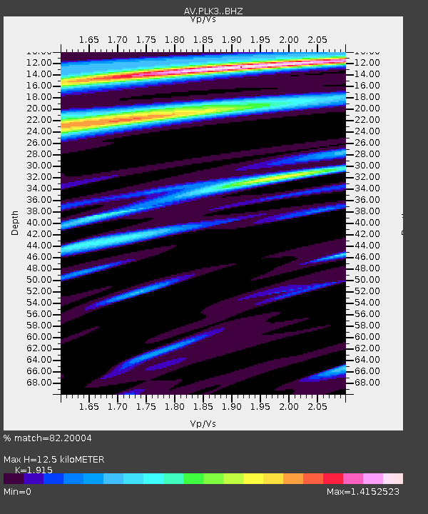
PLK3 Mt. Peulik Volcano 3, Alaska - Earthquake Result Viewer
| Earthquake location: |
Kuril Islands |
| Earthquake latitude/longitude: |
48.5/154.8 |
| Earthquake time(UTC): |
2018/08/10 (222) 18:12:05 GMT |
| Earthquake Depth: |
16 km |
| Earthquake Magnitude: |
5.9 Mww |
| Earthquake Catalog/Contributor: |
NEIC PDE/us |
|
| Network: |
AV Alaska Volcano Observatory |
| Station: |
PLK3 Mt. Peulik Volcano 3, Alaska |
| Lat/Lon: |
57.69 N/156.27 W |
| Elevation: |
494 m |
|
| Distance: |
30.2 deg |
| Az: |
53.647 deg |
| Baz: |
273.68 deg |
| Ray Param: |
0.07938821 |
| Estimated Moho Depth: |
12.5 km |
| Estimated Crust Vp/Vs: |
1.91 |
| Assumed Crust Vp: |
6.1 km/s |
| Estimated Crust Vs: |
3.185 km/s |
| Estimated Crust Poisson's Ratio: |
0.31 |
|
| Radial Match: |
82.20004 % |
| Radial Bump: |
400 |
| Transverse Match: |
61.649895 % |
| Transverse Bump: |
400 |
| SOD ConfigId: |
13570011 |
| Insert Time: |
2019-04-30 18:29:45.224 +0000 |
| GWidth: |
2.5 |
| Max Bumps: |
400 |
| Tol: |
0.001 |
|

Signal To Noise
| Channel | StoN | STA | LTA |
| AV:PLK3: :BHZ:20180810T18:17:44.040006Z | 5.710258 | 5.724142E-7 | 1.00243135E-7 |
| AV:PLK3: :BHN:20180810T18:17:44.040006Z | 2.4258692 | 1.8663495E-7 | 7.693529E-8 |
| AV:PLK3: :BHE:20180810T18:17:44.040006Z | 2.1987865 | 2.2507353E-7 | 1.0236262E-7 |
| Arrivals |
| Ps | 2.0 SECOND |
| PpPs | 5.6 SECOND |
| PsPs/PpSs | 7.6 SECOND |


