You are here: Home > Network List > TA - USArray Transportable Network (new EarthScope stations) Stations List
> Station C11A Tepee Creek (NFS), Magee, ID, USA > Earthquake Result Viewer
C11A Tepee Creek (NFS), Magee, ID, USA - Earthquake Result Viewer
| Earthquake location: |
Tonga Islands |
| Earthquake latitude/longitude: |
-20.8/-173.3 |
| Earthquake time(UTC): |
2008/06/26 (178) 21:19:15 GMT |
| Earthquake Depth: |
38 km |
| Earthquake Magnitude: |
6.0 MB, 5.8 MS, 6.2 MW, 6.1 MW |
| Earthquake Catalog/Contributor: |
WHDF/NEIC |
|
| Network: |
TA USArray Transportable Network (new EarthScope stations) |
| Station: |
C11A Tepee Creek (NFS), Magee, ID, USA |
| Lat/Lon: |
47.84 N/116.26 W |
| Elevation: |
914 m |
|
| Distance: |
85.3 deg |
| Az: |
34.573 deg |
| Baz: |
232.023 deg |
| Ray Param: |
0.04481332 |
| Estimated Moho Depth: |
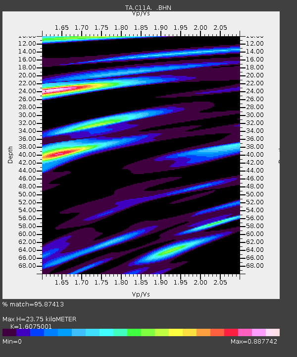
23.75 km |
| Estimated Crust Vp/Vs: |
1.61 |
| Assumed Crust Vp: |
6.571 km/s |
| Estimated Crust Vs: |
4.088 km/s |
| Estimated Crust Poisson's Ratio: |
0.18 |
|
| Radial Match: |
95.87413 % |
| Radial Bump: |
400 |
| Transverse Match: |
83.84849 % |
| Transverse Bump: |
400 |
| SOD ConfigId: |
2504 |
| Insert Time: |
2010-03-06 13:39:46.858 +0000 |
| GWidth: |
2.5 |
| Max Bumps: |
400 |
| Tol: |
0.001 |
|

Signal To Noise
| Channel | StoN | STA | LTA |
| TA:C11A: :BHN:20080626T21:31:17.324019Z | 42.625076 | 2.4140502E-6 | 5.663451E-8 |
| TA:C11A: :BHE:20080626T21:31:17.324019Z | 12.706891 | 5.577663E-7 | 4.389479E-8 |
| TA:C11A: :BHZ:20080626T21:31:17.324019Z | 14.686824 | 6.068203E-7 | 4.1317325E-8 |
| Arrivals |
| Ps | 2.3 SECOND |
| PpPs | 9.2 SECOND |
| PsPs/PpSs | 11 SECOND |


