You are here: Home > Network List > CC - Cascade Chain Volcano Monitoring Stations List
> Station PR04 Puyallup River 04 > Earthquake Result Viewer
PR04 Puyallup River 04 - Earthquake Result Viewer
| Earthquake location: |
Kuril Islands |
| Earthquake latitude/longitude: |
48.5/154.8 |
| Earthquake time(UTC): |
2018/08/10 (222) 18:12:05 GMT |
| Earthquake Depth: |
16 km |
| Earthquake Magnitude: |
5.9 Mww |
| Earthquake Catalog/Contributor: |
NEIC PDE/us |
|
| Network: |
CC Cascade Chain Volcano Monitoring |
| Station: |
PR04 Puyallup River 04 |
| Lat/Lon: |
46.93 N/121.99 W |
| Elevation: |
908 m |
|
| Distance: |
53.3 deg |
| Az: |
58.052 deg |
| Baz: |
304.516 deg |
| Ray Param: |
0.06615957 |
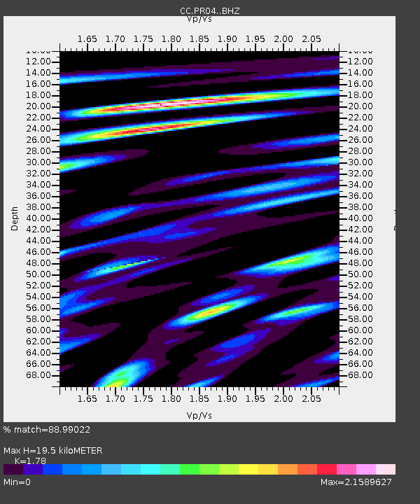
| Estimated Moho Depth: |
19.5 km |
| Estimated Crust Vp/Vs: |
1.78 |
| Assumed Crust Vp: |
6.597 km/s |
| Estimated Crust Vs: |
3.706 km/s |
| Estimated Crust Poisson's Ratio: |
0.27 |
|
| Radial Match: |
88.99022 % |
| Radial Bump: |
400 |
| Transverse Match: |
74.80053 % |
| Transverse Bump: |
400 |
| SOD ConfigId: |
13570011 |
| Insert Time: |
2019-04-30 18:30:46.092 +0000 |
| GWidth: |
2.5 |
| Max Bumps: |
400 |
| Tol: |
0.001 |
|

Signal To Noise
| Channel | StoN | STA | LTA |
| CC:PR04: :BHZ:20180810T18:20:52.380002Z | 11.107747 | 1.1005861E-6 | 9.9082754E-8 |
| CC:PR04: :BHN:20180810T18:20:52.380002Z | 4.854975 | 4.334786E-7 | 8.928544E-8 |
| CC:PR04: :BHE:20180810T18:20:52.380002Z | 6.6144924 | 6.5514547E-7 | 9.904697E-8 |
| Arrivals |
| Ps | 2.4 SECOND |
| PpPs | 7.8 SECOND |
| PsPs/PpSs | 10 SECOND |


