You are here: Home > Network List > TA - USArray Transportable Network (new EarthScope stations) Stations List
> Station C11A Tepee Creek (NFS), Magee, ID, USA > Earthquake Result Viewer
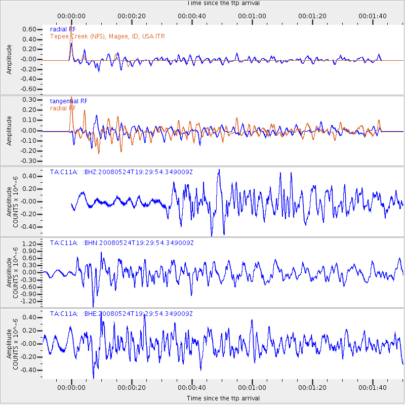
C11A Tepee Creek (NFS), Magee, ID, USA - Earthquake Result Viewer
*The percent match for this event was below the threshold and hence no stack was calculated.
| Earthquake location: |
Colombia |
| Earthquake latitude/longitude: |
4.3/-73.8 |
| Earthquake time(UTC): |
2008/05/24 (145) 19:20:42 GMT |
| Earthquake Depth: |
8.9 km |
| Earthquake Magnitude: |
5.6 MB, 5.6 MS, 5.9 MW, 5.9 MW |
| Earthquake Catalog/Contributor: |
WHDF/NEIC |
|
| Network: |
TA USArray Transportable Network (new EarthScope stations) |
| Station: |
C11A Tepee Creek (NFS), Magee, ID, USA |
| Lat/Lon: |
47.84 N/116.26 W |
| Elevation: |
914 m |
|
| Distance: |
56.6 deg |
| Az: |
326.961 deg |
| Baz: |
126.194 deg |
| Ray Param: |
$rayparam |
*The percent match for this event was below the threshold and hence was not used in the summary stack. |
|
| Radial Match: |
66.81676 % |
| Radial Bump: |
400 |
| Transverse Match: |
53.871452 % |
| Transverse Bump: |
400 |
| SOD ConfigId: |
2504 |
| Insert Time: |
2010-03-06 13:40:05.783 +0000 |
| GWidth: |
2.5 |
| Max Bumps: |
400 |
| Tol: |
0.001 |
|
Signal To Noise
| Channel | StoN | STA | LTA |
| TA:C11A: :BHN:20080524T19:29:54.349009Z | 3.1544743 | 2.5598573E-7 | 8.115004E-8 |
| TA:C11A: :BHE:20080524T19:29:54.349009Z | 1.7016919 | 1.4589217E-7 | 8.57336E-8 |
| TA:C11A: :BHZ:20080524T19:29:54.349009Z | 2.2817588 | 1.374835E-7 | 6.02533E-8 |
| Arrivals |
| Ps | |
| PpPs | |
| PsPs/PpSs | |


