You are here: Home > Network List > CI - Caltech Regional Seismic Network Stations List
> Station SWS Sam W. Stewart, Westmorland, CA, USA > Earthquake Result Viewer
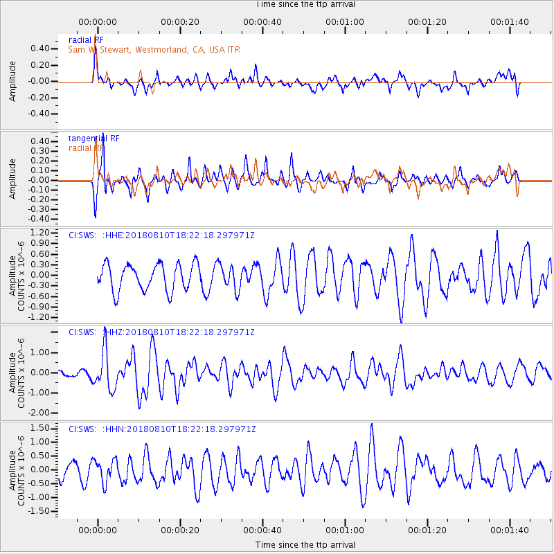
SWS Sam W. Stewart, Westmorland, CA, USA - Earthquake Result Viewer
*The percent match for this event was below the threshold and hence no stack was calculated.
| Earthquake location: |
Kuril Islands |
| Earthquake latitude/longitude: |
48.5/154.8 |
| Earthquake time(UTC): |
2018/08/10 (222) 18:12:05 GMT |
| Earthquake Depth: |
16 km |
| Earthquake Magnitude: |
5.9 Mww |
| Earthquake Catalog/Contributor: |
NEIC PDE/us |
|
| Network: |
CI Caltech Regional Seismic Network |
| Station: |
SWS Sam W. Stewart, Westmorland, CA, USA |
| Lat/Lon: |
32.94 N/115.80 W |
| Elevation: |
140 m |
|
| Distance: |
65.8 deg |
| Az: |
67.172 deg |
| Baz: |
313.161 deg |
| Ray Param: |
$rayparam |
*The percent match for this event was below the threshold and hence was not used in the summary stack. |
|
| Radial Match: |
60.667355 % |
| Radial Bump: |
400 |
| Transverse Match: |
70.49656 % |
| Transverse Bump: |
344 |
| SOD ConfigId: |
13570011 |
| Insert Time: |
2019-04-30 18:31:42.376 +0000 |
| GWidth: |
2.5 |
| Max Bumps: |
400 |
| Tol: |
0.001 |
|
Signal To Noise
| Channel | StoN | STA | LTA |
| CI:SWS: :HHZ:20180810T18:22:18.297971Z | 6.070069 | 9.715696E-7 | 1.6005907E-7 |
| CI:SWS: :HHN:20180810T18:22:18.297971Z | 1.9168533 | 4.05836E-7 | 2.1171991E-7 |
| CI:SWS: :HHE:20180810T18:22:18.297971Z | 0.8900908 | 3.3289092E-7 | 3.7399656E-7 |
| Arrivals |
| Ps | |
| PpPs | |
| PsPs/PpSs | |


