You are here: Home > Network List > TA - USArray Transportable Network (new EarthScope stations) Stations List
> Station C11A Tepee Creek (NFS), Magee, ID, USA > Earthquake Result Viewer
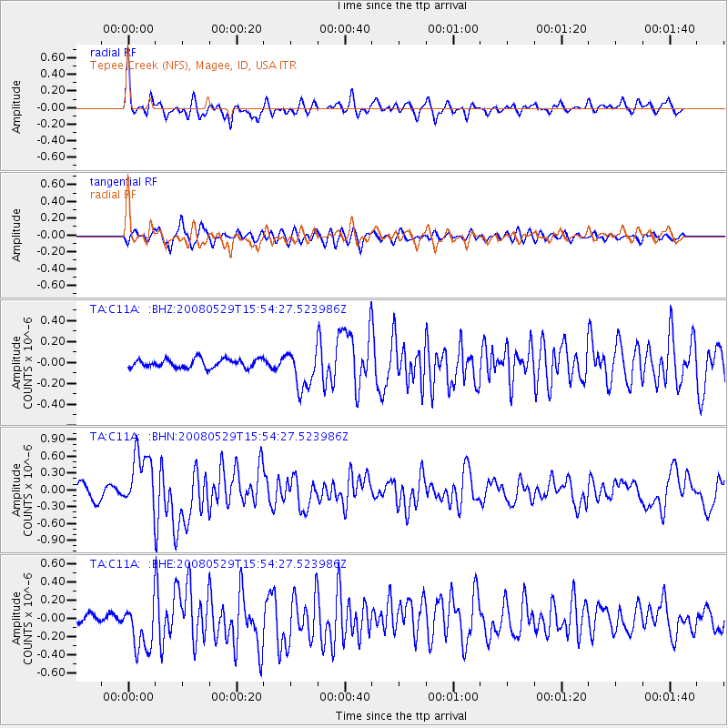
C11A Tepee Creek (NFS), Magee, ID, USA - Earthquake Result Viewer
*The percent match for this event was below the threshold and hence no stack was calculated.
| Earthquake location: |
Iceland |
| Earthquake latitude/longitude: |
64.0/-21.0 |
| Earthquake time(UTC): |
2008/05/29 (150) 15:46:00 GMT |
| Earthquake Depth: |
10 km |
| Earthquake Magnitude: |
6.0 MB, 6.2 MS, 6.3 MW, 6.2 MW |
| Earthquake Catalog/Contributor: |
WHDF/NEIC |
|
| Network: |
TA USArray Transportable Network (new EarthScope stations) |
| Station: |
C11A Tepee Creek (NFS), Magee, ID, USA |
| Lat/Lon: |
47.84 N/116.26 W |
| Elevation: |
914 m |
|
| Distance: |
50.5 deg |
| Az: |
299.59 deg |
| Baz: |
34.669 deg |
| Ray Param: |
$rayparam |
*The percent match for this event was below the threshold and hence was not used in the summary stack. |
|
| Radial Match: |
76.34767 % |
| Radial Bump: |
400 |
| Transverse Match: |
69.60243 % |
| Transverse Bump: |
400 |
| SOD ConfigId: |
2504 |
| Insert Time: |
2010-03-06 13:40:10.993 +0000 |
| GWidth: |
2.5 |
| Max Bumps: |
400 |
| Tol: |
0.001 |
|
Signal To Noise
| Channel | StoN | STA | LTA |
| TA:C11A: :BHN:20080529T15:54:27.523986Z | 5.429944 | 5.2683583E-7 | 9.702418E-8 |
| TA:C11A: :BHE:20080529T15:54:27.523986Z | 5.437489 | 2.61484E-7 | 4.8089102E-8 |
| TA:C11A: :BHZ:20080529T15:54:27.523986Z | 4.5570436 | 1.8710203E-7 | 4.105777E-8 |
| Arrivals |
| Ps | |
| PpPs | |
| PsPs/PpSs | |


