You are here: Home > Network List > CI - Caltech Regional Seismic Network Stations List
> Station PHL Parkhill, California, USA > Earthquake Result Viewer
PHL Parkhill, California, USA - Earthquake Result Viewer
| Earthquake location: |
Near East Coast Of Kamchatka |
| Earthquake latitude/longitude: |
54.8/162.0 |
| Earthquake time(UTC): |
1997/12/05 (339) 11:26:54 GMT |
| Earthquake Depth: |
33 km |
| Earthquake Magnitude: |
6.3 MB, 7.6 MS, 7.9 UNKNOWN, 7.3 ME |
| Earthquake Catalog/Contributor: |
WHDF/NEIC |
|
| Network: |
CI Caltech Regional Seismic Network |
| Station: |
PHL Parkhill, California, USA |
| Lat/Lon: |
35.41 N/120.55 W |
| Elevation: |
351 m |
|
| Distance: |
55.0 deg |
| Az: |
76.697 deg |
| Baz: |
316.441 deg |
| Ray Param: |
0.065016344 |
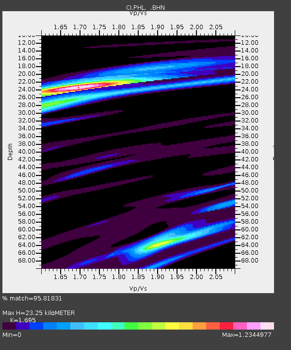
| Estimated Moho Depth: |
23.25 km |
| Estimated Crust Vp/Vs: |
1.70 |
| Assumed Crust Vp: |
6.183 km/s |
| Estimated Crust Vs: |
3.648 km/s |
| Estimated Crust Poisson's Ratio: |
0.23 |
|
| Radial Match: |
95.81831 % |
| Radial Bump: |
305 |
| Transverse Match: |
85.01394 % |
| Transverse Bump: |
400 |
| SOD ConfigId: |
3770 |
| Insert Time: |
2010-02-26 02:10:42.268 +0000 |
| GWidth: |
2.5 |
| Max Bumps: |
400 |
| Tol: |
0.001 |
|
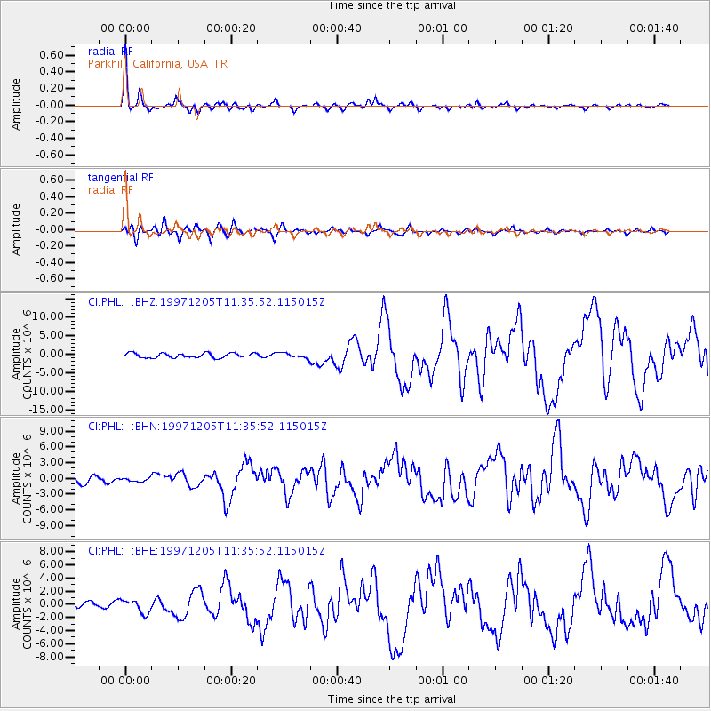
Signal To Noise
| Channel | StoN | STA | LTA |
| CI:PHL: :BHN:19971205T11:35:52.115015Z | 0.54001886 | 3.3253178E-7 | 6.157781E-7 |
| CI:PHL: :BHE:19971205T11:35:52.115015Z | 1.813169 | 1.0044963E-6 | 5.540004E-7 |
| CI:PHL: :BHZ:19971205T11:35:52.115015Z | 1.0496734 | 6.7533256E-7 | 6.4337394E-7 |
| Arrivals |
| Ps | 2.7 SECOND |
| PpPs | 9.6 SECOND |
| PsPs/PpSs | 12 SECOND |


