You are here: Home > Network List > TA - USArray Transportable Network (new EarthScope stations) Stations List
> Station C11A Tepee Creek (NFS), Magee, ID, USA > Earthquake Result Viewer
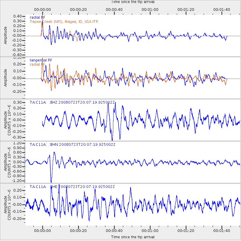
C11A Tepee Creek (NFS), Magee, ID, USA - Earthquake Result Viewer
*The percent match for this event was below the threshold and hence no stack was calculated.
| Earthquake location: |
Sichuan, China |
| Earthquake latitude/longitude: |
32.7/105.5 |
| Earthquake time(UTC): |
2008/07/23 (205) 19:54:45 GMT |
| Earthquake Depth: |
10 km |
| Earthquake Magnitude: |
5.7 MB, 5.2 MS, 5.5 MW, 5.5 MW |
| Earthquake Catalog/Contributor: |
WHDF/NEIC |
|
| Network: |
TA USArray Transportable Network (new EarthScope stations) |
| Station: |
C11A Tepee Creek (NFS), Magee, ID, USA |
| Lat/Lon: |
47.84 N/116.26 W |
| Elevation: |
914 m |
|
| Distance: |
91.5 deg |
| Az: |
26.664 deg |
| Baz: |
325.85 deg |
| Ray Param: |
$rayparam |
*The percent match for this event was below the threshold and hence was not used in the summary stack. |
|
| Radial Match: |
74.62634 % |
| Radial Bump: |
400 |
| Transverse Match: |
71.97246 % |
| Transverse Bump: |
400 |
| SOD ConfigId: |
2504 |
| Insert Time: |
2010-03-06 13:40:28.329 +0000 |
| GWidth: |
2.5 |
| Max Bumps: |
400 |
| Tol: |
0.001 |
|
Signal To Noise
| Channel | StoN | STA | LTA |
| TA:C11A: :BHN:20080723T20:07:19.925002Z | 4.4819016 | 3.6476095E-7 | 8.138531E-8 |
| TA:C11A: :BHE:20080723T20:07:19.925002Z | 1.6755738 | 9.067195E-8 | 5.4113972E-8 |
| TA:C11A: :BHZ:20080723T20:07:19.925002Z | 1.6295526 | 1.0771155E-7 | 6.609885E-8 |
| Arrivals |
| Ps | |
| PpPs | |
| PsPs/PpSs | |


