You are here: Home > Network List > US - United States National Seismic Network Stations List
> Station WUAZ Wupatki, Arizona, USA > Earthquake Result Viewer
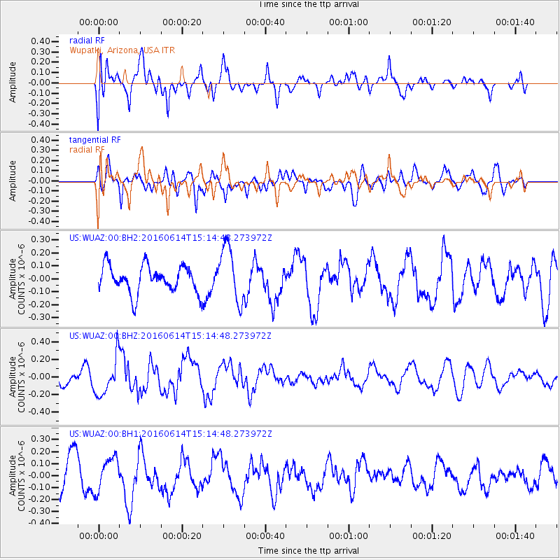
WUAZ Wupatki, Arizona, USA - Earthquake Result Viewer
*The percent match for this event was below the threshold and hence no stack was calculated.
| Earthquake location: |
Southeast Of Ryukyu Islands |
| Earthquake latitude/longitude: |
26.9/130.2 |
| Earthquake time(UTC): |
2016/06/14 (166) 15:01:56 GMT |
| Earthquake Depth: |
6.0 km |
| Earthquake Magnitude: |
5.6 MWW |
| Earthquake Catalog/Contributor: |
NEIC PDE/NEIC COMCAT |
|
| Network: |
US United States National Seismic Network |
| Station: |
WUAZ Wupatki, Arizona, USA |
| Lat/Lon: |
35.52 N/111.37 W |
| Elevation: |
1592 m |
|
| Distance: |
94.9 deg |
| Az: |
46.056 deg |
| Baz: |
308.015 deg |
| Ray Param: |
$rayparam |
*The percent match for this event was below the threshold and hence was not used in the summary stack. |
|
| Radial Match: |
71.644554 % |
| Radial Bump: |
400 |
| Transverse Match: |
68.67415 % |
| Transverse Bump: |
400 |
| SOD ConfigId: |
1609551 |
| Insert Time: |
2016-06-28 15:03:01.444 +0000 |
| GWidth: |
2.5 |
| Max Bumps: |
400 |
| Tol: |
0.001 |
|
Signal To Noise
| Channel | StoN | STA | LTA |
| US:WUAZ:00:BHZ:20160614T15:14:48.273972Z | 1.7610114 | 2.2053757E-7 | 1.2523348E-7 |
| US:WUAZ:00:BH1:20160614T15:14:48.273972Z | 1.0169283 | 1.3450615E-7 | 1.3226709E-7 |
| US:WUAZ:00:BH2:20160614T15:14:48.273972Z | 2.130901 | 2.2172516E-7 | 1.04052305E-7 |
| Arrivals |
| Ps | |
| PpPs | |
| PsPs/PpSs | |


