You are here: Home > Network List > TA - USArray Transportable Network (new EarthScope stations) Stations List
> Station C11A Tepee Creek (NFS), Magee, ID, USA > Earthquake Result Viewer
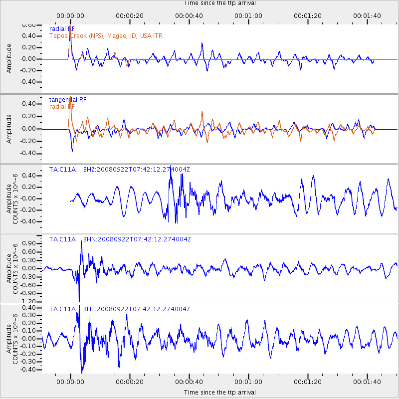
C11A Tepee Creek (NFS), Magee, ID, USA - Earthquake Result Viewer
*The percent match for this event was below the threshold and hence no stack was calculated.
| Earthquake location: |
Hokkaido, Japan Region |
| Earthquake latitude/longitude: |
41.6/140.4 |
| Earthquake time(UTC): |
2008/09/22 (266) 07:31:59 GMT |
| Earthquake Depth: |
149 km |
| Earthquake Magnitude: |
5.7 MW, 5.3 MB, 5.6 MW |
| Earthquake Catalog/Contributor: |
WHDF/NEIC |
|
| Network: |
TA USArray Transportable Network (new EarthScope stations) |
| Station: |
C11A Tepee Creek (NFS), Magee, ID, USA |
| Lat/Lon: |
47.84 N/116.26 W |
| Elevation: |
914 m |
|
| Distance: |
68.1 deg |
| Az: |
44.945 deg |
| Baz: |
308.119 deg |
| Ray Param: |
$rayparam |
*The percent match for this event was below the threshold and hence was not used in the summary stack. |
|
| Radial Match: |
49.577583 % |
| Radial Bump: |
264 |
| Transverse Match: |
57.84636 % |
| Transverse Bump: |
329 |
| SOD ConfigId: |
2560 |
| Insert Time: |
2010-03-06 13:40:45.533 +0000 |
| GWidth: |
2.5 |
| Max Bumps: |
400 |
| Tol: |
0.001 |
|
Signal To Noise
| Channel | StoN | STA | LTA |
| TA:C11A: :BHN:20080922T07:42:12.274004Z | 3.906634 | 3.7637054E-7 | 9.634138E-8 |
| TA:C11A: :BHE:20080922T07:42:12.274004Z | 2.4483967 | 2.1847954E-7 | 8.9233716E-8 |
| TA:C11A: :BHZ:20080922T07:42:12.274004Z | 1.9850538 | 2.3414515E-7 | 1.1795406E-7 |
| Arrivals |
| Ps | |
| PpPs | |
| PsPs/PpSs | |


