You are here: Home > Network List > MU - Miami University Seismic Network Stations List
> Station MUM1 Monroe > Earthquake Result Viewer
MUM1 Monroe - Earthquake Result Viewer
| Earthquake location: |
Kuril Islands |
| Earthquake latitude/longitude: |
48.5/154.8 |
| Earthquake time(UTC): |
2018/08/10 (222) 18:12:05 GMT |
| Earthquake Depth: |
16 km |
| Earthquake Magnitude: |
5.9 Mww |
| Earthquake Catalog/Contributor: |
NEIC PDE/us |
|
| Network: |
MU Miami University Seismic Network |
| Station: |
MUM1 Monroe |
| Lat/Lon: |
39.65 N/81.15 W |
| Elevation: |
310 m |
|
| Distance: |
79.3 deg |
| Az: |
40.613 deg |
| Baz: |
325.869 deg |
| Ray Param: |
0.049076866 |
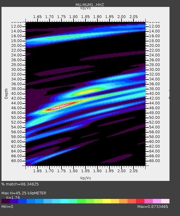
| Estimated Moho Depth: |
45.25 km |
| Estimated Crust Vp/Vs: |
1.74 |
| Assumed Crust Vp: |
6.207 km/s |
| Estimated Crust Vs: |
3.567 km/s |
| Estimated Crust Poisson's Ratio: |
0.25 |
|
| Radial Match: |
86.34625 % |
| Radial Bump: |
400 |
| Transverse Match: |
79.88885 % |
| Transverse Bump: |
400 |
| SOD ConfigId: |
13570011 |
| Insert Time: |
2019-04-30 18:35:14.927 +0000 |
| GWidth: |
2.5 |
| Max Bumps: |
400 |
| Tol: |
0.001 |
|

Signal To Noise
| Channel | StoN | STA | LTA |
| MU:MUM1: :HHZ:20180810T18:23:38.280027Z | 8.080031 | 2.7268813E-6 | 3.37484E-7 |
| MU:MUM1: :HHN:20180810T18:23:38.280027Z | 3.0875115 | 1.0374556E-6 | 3.3601674E-7 |
| MU:MUM1: :HHE:20180810T18:23:38.280027Z | 2.8220475 | 8.027575E-7 | 2.8445925E-7 |
| Arrivals |
| Ps | 5.5 SECOND |
| PpPs | 19 SECOND |
| PsPs/PpSs | 25 SECOND |


