You are here: Home > Network List > N4 - Central and EAstern US Network Stations List
> Station 255A Hazlehurst, GA, USA > Earthquake Result Viewer
255A Hazlehurst, GA, USA - Earthquake Result Viewer
| Earthquake location: |
Kuril Islands |
| Earthquake latitude/longitude: |
48.5/154.8 |
| Earthquake time(UTC): |
2018/08/10 (222) 18:12:05 GMT |
| Earthquake Depth: |
16 km |
| Earthquake Magnitude: |
5.9 Mww |
| Earthquake Catalog/Contributor: |
NEIC PDE/us |
|
| Network: |
N4 Central and EAstern US Network |
| Station: |
255A Hazlehurst, GA, USA |
| Lat/Lon: |
31.93 N/82.48 W |
| Elevation: |
45 m |
|
| Distance: |
85.0 deg |
| Az: |
45.877 deg |
| Baz: |
325.818 deg |
| Ray Param: |
0.04504854 |
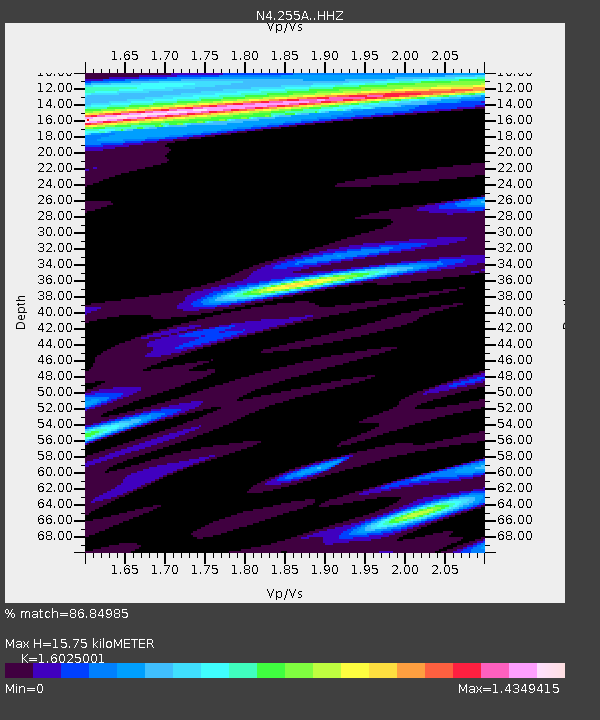
| Estimated Moho Depth: |
15.75 km |
| Estimated Crust Vp/Vs: |
1.60 |
| Assumed Crust Vp: |
6.565 km/s |
| Estimated Crust Vs: |
4.096 km/s |
| Estimated Crust Poisson's Ratio: |
0.18 |
|
| Radial Match: |
86.84985 % |
| Radial Bump: |
400 |
| Transverse Match: |
70.883804 % |
| Transverse Bump: |
400 |
| SOD ConfigId: |
13570011 |
| Insert Time: |
2019-04-30 18:35:22.547 +0000 |
| GWidth: |
2.5 |
| Max Bumps: |
400 |
| Tol: |
0.001 |
|

Signal To Noise
| Channel | StoN | STA | LTA |
| N4:255A: :HHZ:20180810T18:24:08.400022Z | 8.057908 | 1.6110533E-6 | 1.9993443E-7 |
| N4:255A: :HHN:20180810T18:24:08.400022Z | 0.82317024 | 2.1758764E-7 | 2.6432883E-7 |
| N4:255A: :HHE:20180810T18:24:08.400022Z | 0.7178263 | 3.094439E-7 | 4.310846E-7 |
| Arrivals |
| Ps | 1.5 SECOND |
| PpPs | 6.1 SECOND |
| PsPs/PpSs | 7.6 SECOND |


