You are here: Home > Network List > N4 - Central and EAstern US Network Stations List
> Station I40B Norwalk, WI, USA > Earthquake Result Viewer
I40B Norwalk, WI, USA - Earthquake Result Viewer
| Earthquake location: |
Kuril Islands |
| Earthquake latitude/longitude: |
48.5/154.8 |
| Earthquake time(UTC): |
2018/08/10 (222) 18:12:05 GMT |
| Earthquake Depth: |
16 km |
| Earthquake Magnitude: |
5.9 Mww |
| Earthquake Catalog/Contributor: |
NEIC PDE/us |
|
| Network: |
N4 Central and EAstern US Network |
| Station: |
I40B Norwalk, WI, USA |
| Lat/Lon: |
43.89 N/90.62 W |
| Elevation: |
419 m |
|
| Distance: |
71.6 deg |
| Az: |
43.839 deg |
| Baz: |
320.388 deg |
| Ray Param: |
0.05419441 |
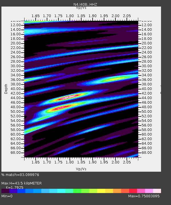
| Estimated Moho Depth: |
43.5 km |
| Estimated Crust Vp/Vs: |
1.79 |
| Assumed Crust Vp: |
6.53 km/s |
| Estimated Crust Vs: |
3.643 km/s |
| Estimated Crust Poisson's Ratio: |
0.27 |
|
| Radial Match: |
83.099976 % |
| Radial Bump: |
385 |
| Transverse Match: |
74.430176 % |
| Transverse Bump: |
400 |
| SOD ConfigId: |
13570011 |
| Insert Time: |
2019-04-30 18:35:42.966 +0000 |
| GWidth: |
2.5 |
| Max Bumps: |
400 |
| Tol: |
0.001 |
|

Signal To Noise
| Channel | StoN | STA | LTA |
| N4:I40B: :HHZ:20180810T18:22:54.549985Z | 10.8074875 | 7.9837673E-7 | 7.3872556E-8 |
| N4:I40B: :HHN:20180810T18:22:54.549985Z | 2.7599993 | 2.6255762E-7 | 9.51296E-8 |
| N4:I40B: :HHE:20180810T18:22:54.549985Z | 2.666677 | 2.448158E-7 | 9.180557E-8 |
| Arrivals |
| Ps | 5.5 SECOND |
| PpPs | 18 SECOND |
| PsPs/PpSs | 23 SECOND |


